New ScanMagic v.2.0
ScanEx R&D Center (Russia) has released version 2.0 of ScanMagic software, designed for Earth remote sensing data processing. The updated version supports popular cartographic services of Google, Microsoft and Yahoo....
ScanEx R&D Center (Russia) has released version 2.0 of ScanMagic software, designed for Earth remote sensing data processing. The updated version supports popular cartographic services of Google, Microsoft and Yahoo....
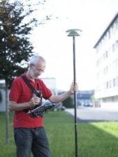
Leica Geosystems (Swizerland) has released Leica MobileMatriX version 2.0; a multi-sensors GIS solution for capturing GIS data directly in the field. The new version 2.0 now supports Leica ATX1230 GG...
Leica SpiderWeb version 2.0 has been extended with additional features and services that improve the usability and efficiency for both service users and service providers. Leica SpiderWeb is easy to...
Version 2.0 of Leica GeoMoS has been released. This is a solution for multi-sensor structural monitoring using a range of high precision geodetic instruments from Leica Geosystems and third-party sensors....
DM Solutions Group (Canada) has made available Chameleon version 2.0, an Open Source software for creating customisable Web mapping applications. This latest version provides the flexibility to utilise both remote...
This is our third Product Survey (PS) on Terrestrial Laser Scanners (TLS). The first was published in January 2001 and the second in December 2004. A lot has changed since...
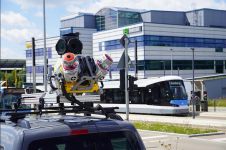
Trimble has recently unveiled the Trimble MX90 mobile mapping system. Integrating advanced Trimble GNSS and inertial technology with Trimble field and office software, the MX90 offers a comprehensive field-to-finish mobile...
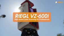
Extremely high speed and highest accuracy make the RIEGL VZ-600i 3D terrestrial laser scanner a most profitable tool for surveyors. Data acquisition – especially of large projects in construction, AEC...
Both overview and detail are necessary during all phases of disaster management: preparedness, prevention, emergency response, recovery, mitigation and damage assessment; and both can be simultaneously provided by earth observation...
This site uses cookies. By continuing to use this website, you agree to our Cookies Policy. Agree