Urban Planning of Stockholm in 3D
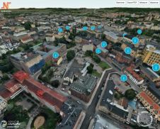
Stockholm Municipality has set up an appealing way of communicating its future urban projects. In the Culture House of Stockholm City, a large touchscreen is available allowing citizens to 'fly'...

Stockholm Municipality has set up an appealing way of communicating its future urban projects. In the Culture House of Stockholm City, a large touchscreen is available allowing citizens to 'fly'...
Planners and other industry leaders are invited to discuss the impact that social media and the GeoWeb have on their field at the online Spatial Roundtable. ESRI Community Development industry...
SuperGeo from Taiwan has completed a geographic information system (GIS) for disaster prevention and planning. Located in the Circum-Pacific seismic zone, Taiwan frequently experiences high-magnitude earthquakes throughout the country. Thus,...
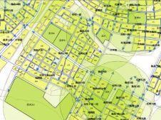
The City of Norrköping, Sweden, has empowered its citizens to plan the future city centre. The project was initiated by the city planning office of Norrköping to communicate plans for...
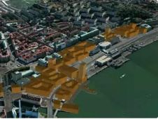
City of Gothenburg, Sweden, and its partner Agency9 received the Geospatial World Innovation and Excellence Award in Urban Planning at the opening of the internationally renowned Geospatial World Forum 2012...

Traditional methods of information management are hard to use in the planning process of problematic urban areas such as squatter settlements. GIS provides the capability for dynamic query and analysis,...

As more and more cities are deciding to work with a digital twin, we have selected a number of articles that outline how digital twins are created and how they...
PlanetScope is now accessible on Google Cloud Marketplace. This availability of Planet's flagship satellite imaging product contributes to the company's mission to democratize access to near-daily satellite imagery, enabling organizations...

Linda Foster oversees Esri’s worldwide strategic vision for land administration and surveying. With 20 years of experience working in the land and resource industry, she is a registered professional land...

There are indications that today’s technological advances are putting a fully operational multipurpose cadastre within reach, following decades of a global vision and small-scale progress towards a comprehensive map-centric land...
This site uses cookies. By continuing to use this website, you agree to our Cookies Policy. Agree