3D Repo Develop Health and Safety Virtual Reality App
Repo is working with Balfour Beatty, Vinci and Highways England to deploy a Virtual Reality (VR) simulation for Zero Harm Health and Safety Training. Part of the Smart Motorway programme,...
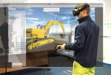
Repo is working with Balfour Beatty, Vinci and Highways England to deploy a Virtual Reality (VR) simulation for Zero Harm Health and Safety Training. Part of the Smart Motorway programme,...

Virtual reality (VR) is a computer-generated representation of a three-dimensional image or environment. Usually paired with a headset, it gives the user a fully immersive experience. It is now being...

The industry keynote speaker has been announced for INTERACT – The Luciad User Conference 2016. Professor Henk Scholten of Dutch geospatial solutions provider Geodan will provide the industry keynote for...
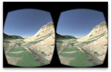
The spectacular setting of Ben Nevis provides the backdrop for an Oculus Rift game created by Ordnance Survey (OS) developers, in which players race against the clock to find a hidden...

Leica Geosystems, part of Hexagon, has officially announced the Leica BLK2GO PULSE. This innovative first-person laser scanner merges state-of-the-art Lidar sensor technology with the iconic Leica BLK2GO design, representing a...

There are indications that today’s technological advances are putting a fully operational multipurpose cadastre within reach, following decades of a global vision and small-scale progress towards a comprehensive map-centric land...
Stonex has launched a new SLAM solution for fast and efficient large-area surveys: the X70GO SLAM laser scanner. It combines mobile scanning with a stationary mode to scan with higher...

Global reference systems such as the International Terrestrial Reference Frame provide the foundation for determining positions on Earth and in space, as well as for reliably quantifying our planet’s changes...

Lidaretto is flexible and compact Lidar scanning system developed since 2015 and uniquely designed to be used the way that fits best to users’ specific application. You can easily mount...
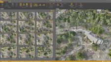
Virtual Surveyor has added drone photogrammetry capabilities to the latest release of its popular Virtual Surveyor smart drone surveying software. The new Terrain Creator app photogrammetrically processes drone photos to...
This site uses cookies. By continuing to use this website, you agree to our Cookies Policy. Agree