Towards a Digitized Citizen-oriented Armenian Cadastre
Armenia is moving towards a more transparent, secure, unified and citizen-oriented cadastral system. To achieve this, digitizing cadastral archives is essential. Digital availabili...
 This month's editorial focus in on land administration and cadastral survey techniques. All countries have to deal with the management of land, as it is a fundamental infrastructure for the sustainable economic and social development of societies. The geomatics industry provides many excellent solutions, which are being reflected by this selection of articles.

Armenia is moving towards a more transparent, secure, unified and citizen-oriented cadastral system. To achieve this, digitizing cadastral archives is essential. Digital availabili...
A cloud-based cadastre-as-a-service platform in New South Wales (NSW), Australia, has gone live to overhaul the state's approach to managing cadastral data. Representing a major up...
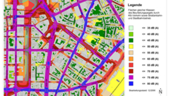
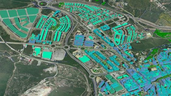
In recent years, Germany's national mapping and cadastre information systems have become increasingly focused on demands for multidimensional applications, e.g. environmental...
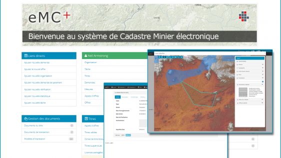
GAF has been awarded a contract to support the Ministry of Mines and Energy in Ouagadougou in establishing a new computerised mining cadastre and registry system in Burkina Faso. T...

The European Association of Aerial Surveying Industries (EAASI) has extended the mandate of the executive committee to continue to promote the benefits of aerial surveying to the w...

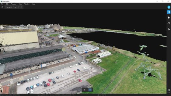
Mapping 21 Quarries in 60 Days The mission was to capture 21 quarries in 60 days. Squeezed into that timeframe were planning and performing the UAV photogrammetry flights, editing...
Coal is falling out of favour, resulting in power plant closures. Mapping is a first step in the site redevelopment process, but data collection can be tricky. UAV mapping has prov...
Every month we will focus on a specific theme, featuring a selection of articles which have previously been published in GIM International magazine, to present a complete recap of the subject. If you don't want to miss these themed recaps, sign up for the newsletter (sign up here).
Follow GIM International on Facebook, LinkedIn, Twitter or sign up for the newsletter! Don't miss the latest developments: join GIM International!
 |  |  |  |
| 29.769 SUBSCRIBERS | 22.513 MEMBERS | 9.484 LIKES | 8.739 FOLLOWERS |
This site uses cookies. By continuing to use this website, you agree to our Cookies Policy. Agree