Aibot X6 Replaces Tachymeter
Thanks to the accurate management of the camera resolution and the control of speed, direction and position, the Aibot X6 captures a cartographic area through reinterpretation of conventional photogrammetry. The Aibot X6's characteristics have been tested by Asker Oppmaling AS, Norway. The test area was a 33ha stone quarry near Oslo. Asker compared the conventionally measured ground control points with the ones taken by the Aibot X6. The test revealed that the Aibot X6 makes surveying work much easier and less time-consuming.
A tachymeter was always a must-have for geodesists and the portfolio of surveyors could not be imagined without it. The device, which is used for photogrammetry and initial measurement of points and which is able to determine horizontal directions, vertical angles and slants, will be replaced.
The Aibot X6 hexacopter is an intelligent copter platform, which is distinguished by easy handling and a high degree of robustness.
Taking the example of Norway's stone quarry, only the plain survey time would take about 3 to 4 weeks. The surveyors would have to walk through the mine on foot in order to collect the data. Domains like dangerous cavities or muddy areas are very hard to access, so most of the time they cannot be measured.
The copter with a width of 1.05m and a height of 0.45m can reach areas which are difficult to access. It is able to carry an additional payload of up to 2.5kg and has, due to the CPR frame only an own weight of 2,555g. Consequence of size and weight is the flight stability which enables the copter to get great results even with strong wind. The symbiosis of six rotors and the powerful motor guarantee a tremendous lift and a stable flight altitude. The copter reaches a climb rate of 8m/sec and a speed of 60 km/h. In addition the Aibot can be controlled from a central location. The area has not to be covered by foot. Those qualities are a revolution for surveys and promise a time saving of about ¼ compared to the conventional method using the Tachymeter. This was shown during the test in Norway.
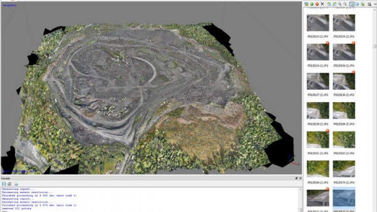
The workflows of mapping with the Aibot X6 are easy. In the preparatory stage the requirements have to be defined. The ground resolution is practicable from 1mm up to 4mm. Parameters like flight height, speed, overlapping and distance of the trigger position can be planned in very short time by the flight planning software AiProFlight from Aibotix. The project requirements of Asker add up to an area of 33ha and a pixel size of 22.7mm. After the requirements have been set the actual flight plan is constructed in order to collect the data. The flight planning is done by the use of the Aibotix AiProFlight Software. Flight direction, resolution, height, route and stereo overlapping will be defined and insert in the mapping device. The flight plan will be constructed and saved by mouse click. At any waypoint assignments like camera position or dwell time can be inserted. As soon as the flight plan is transferred to the Aibot X6 (wireless) it can operate 100% automatically.
In a normal surface flight the pictures will be taken in a 90 degree angle vertical down (nadir). One of the features of the Aibot X6 is the rotatable camera mount which guarantees a flight through a stone quarry and generates a detailed resolution of the vertical walls in an angle of 45 degree (oblique). Picture based 3D-modelling software like the AgiSoft or Enso use georeferenced pictures and build the texture of an orthophoto or a 3D model. A cost-intensive camera calibration is not necessary. The software used has the opportunity to operate a calibration with help of the determined camera parameters additionally to the workflow.

Value staying current with geomatics?
Stay on the map with our expertly curated newsletters.
We provide educational insights, industry updates, and inspiring stories to help you learn, grow, and reach your full potential in your field. Don't miss out - subscribe today and ensure you're always informed, educated, and inspired.
Choose your newsletter(s)


