
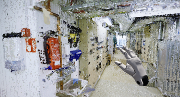
Visualizing point clouds in game engines
How can the dense point clouds that originate from 3D mapping be turned into useful game engine scenes? This article considers issues including point classification and segmentation, geometric accurac...
Technological advancements have one main goal: to make it easier for us to accomplish tasks. Each new technology must show that it has solved a problem, and point cloud modeling is not different. For a long time, conducting land surveys was a bit of a challenge. Surveyors, contractors, and engineers invested numerous resources in these activities, increasing the project costs and periods. Point cloud modeling, a new concept, has since changed this and made it easier to survey work sites.
Point clouds feature an array of data points, with each point comprising X, Y and Z coordinates. Each data point indicates a surface area, creating a 3D structure that surveyors and engineers alike can study. In addition, point clouds are manipulatable to reveal more details about a site, e.g., its terrain and features.
Point cloud modeling is thus the art of creating point clouds, which is possible using LiDAR and photogrammetry.
LiDAR is not necessarily a system. Instead, this term encompasses the tools used in point cloud modeling using remote sensors which collect dimensions from a site and convert these into a 3D model. From objects to environments, these tools map out areas using ultraviolet or near-infrared light. The tools send light pulses and measure how long the pulses take to return to the scanner based on the ground or launched from a drone. Based on the working mechanism of a laser system, the pulses move through a gain medium like those available in EksmaOptics.com for their amplification. The LiDAR tools then convert this pulse to-and-fro time into direction and distance by covering a circle in several sweeps. Finally, the tools create point cloud data in 3D models with X, Y and Z coordinates from each reading. If possible, GPS timestamps are added to the model. LiDAR applies to various materials, including clouds, rocks, rain, and even aerosols. It has proven to be a gem to people working in fields where physical access might not be possible.
While this method has worked great, it comes saddled with a few challenges. First, the beams must have sight access which can be tricky if there is bad weather. Secondly, reflection from surfaces can interfere with data collection.
Rather than relying on laser beams to map out sites, this method uses drones to capture pictures of a site. A camera mounted on the drone does the trick. Given that cameras rely on angles, there is a need to adjust the camera for each site’s environmental conditions. Moreover, the person handling the camera should also adjust the angles to ensure that the pictures get the whole scope.
What follows is the processing of the photos to create an overlap which creates a 3D mesh. The overlaps require reconstructing, where the person creating the mesh must fill in the gaps between the data points. The fewer images and angles there are, the more gaps there will be, increasing the processing time.
While there are other ways to create 3D models, people using point cloud modeling enjoy the benefit of:
Is one point cloud modeling method more effective than the other? As far as accuracy goes, both methods have similar efficacy rates. Therefore, choosing either option comes down to your requirements in the project and how easy it is to implement one of the techniques.
We encourage you to subscribe to our weekly newsletter. Subscribers also receive a digital copy of our bi-monthly magazine.
How can the dense point clouds that originate from 3D mapping be turned into useful game engine scenes? This article considers issues including point classification and segmentation, geometric accurac...
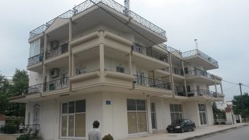
The reconstruction of building outlines provides useful input for land information systems. In the city of Kalochori in northern Greece, a mixed commercial and residential area of 33 hectares was sele...
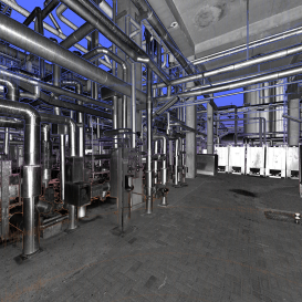
Point cloud datasets have proven to be useful for many applications, ranging from engineering design to asset management. While point clouds are becoming denser and more accurate, new software is allo...
This site uses cookies. By continuing to use this website, you agree to our Cookies Policy. Agree