Elevating knowledge: read our in-depth features

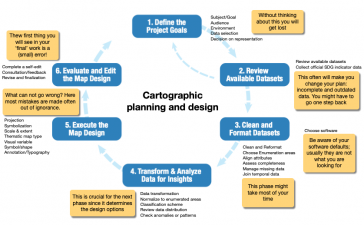
Data visualization is inherent to humans and continuously evolves, driven by innovation. How is GIS playing a role in this? The term 'data visualization' has come into popular usage relatively recentl...
To reflect the changing nature of our industry and attract much-needed future talent, perhaps it’s time to rebrand surveyors as ‘geospatial astronauts’, writes Wim van Wegen in his latest column...

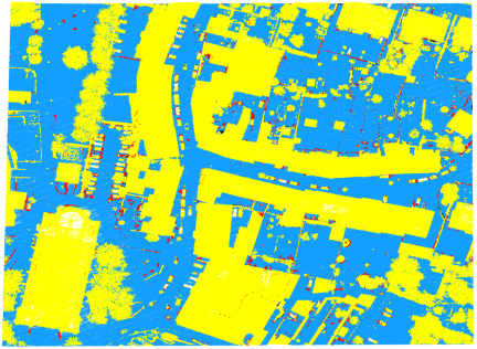
The diversity of relief mapping methods and the existence of large elevation databases intended for multiple users raises the issue of DEM quality. Digital elevation model (DEM) accuracy is commonly a...

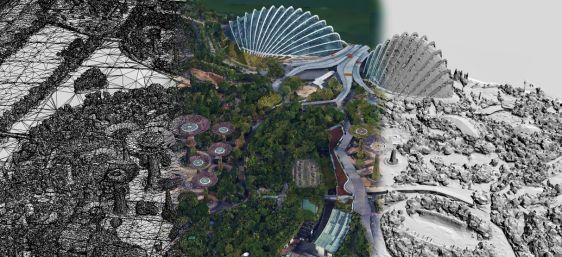
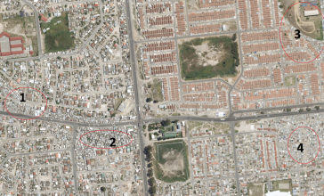
An increasing number of cities are creating 3D city models to support visualization and simulations in the urban planning process. The 3D city models are often extended with planned buildings. One way...
The International Cartographic Association and the United Nations recently published the book Mapping for a sustainable world. The objective was to inform those interested in visualizing SDG indicator...
Due to the local region’s proneness to occasional wildfires, the Geomatics Division at the University of Cape Town, South Africa, has conducted research and project work around the theme of 3D reco...

London Gatwick has created a new geospatial platform using Esri’s ArcGIS to support multiple operational areas at the airport, including engineering and environmental services. The system is already...

RSK Group has awarded a new enterprise GIS contract to Esri UK to boost the use of geospatial technology across its operations and support ambitious growth plans. This three-year agreement, spanning 1...
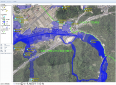
Nestled in the Hiroshima Prefecture of Japan, Higashihiroshima City has unveiled an advanced flood hazard and disaster prevention web GIS application. Powered by the TatukGIS developer kernel (DK) for...

GIS People has unveiled a new e-book resource designed to offer valuable insights into the world of GIS. The e-book is offered entirely free of charge as a means of fostering education and knowledge...

Trimble recently released the Trimble Terra Office add-in for Esri ArcGIS Pro. The add-in is a new product in the Terra Office suite of desktop solutions for integrating Trimble TerraFlex field data c...

In the Open Maps For Europe 2 (OME2) project, national providers of geospatial information will create a prototype for harmonized large-scale, high-value pan-European open datasets. The project aims t...
Our weekly newsletter is an easy way to stay updated with our latest articles, news, and magazines. It's the easiest way to stay current with the industry.
Subscribe to our newsletter(s)Cartography is about describing the world in the form of maps and diagrams. Classic cartography produces paper maps but nowadays this field also encompasses Geographical Information Systems and the products produced by these systems. Cartography is heavily dependent on data from [Remote sensing] and [Land surveying and topography] for the dry part of our world and [marine surveying and bathymetry] for the wet parts of our world.
Cartography / GIS can be found in almost any industry vertical where it transforms the various data sources into products readily useable in for example [land and water management], [climate] and [farming and conservation].
This site uses cookies. By continuing to use this website, you agree to our Cookies Policy. Agree