Using BIM data together with city models
Exploring the opportunities and challenges
An increasing number of cities are creating 3D city models to support visualization and simulations in the urban planning process. The 3D city models are often extended with planned buildings. One way to facilitate this is to add simplified building information modelling (BIM) models of the planned buildings to the 3D city model. This article summarizes some of the recent academic and industrial studies of this topic.
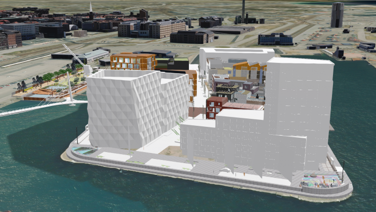
There are several commercial and open-source tools for integrating BIM data into 3D city models (Figure 1). The integration is complicated, as it requires transformation between different information models (ontologies), e.g. between the open BIM format Industry Foundation Classes (IFC) and the open 3D city model format CityGML. The transformation of geometries is also challenging and includes a conversion from solid modelling (used in BIM) to boundary representations (used in city models).
In 2019, a GeoBIM benchmark was launched to study the interoperability in the GeoBIM domain, where GeoBIM stands for an integration between city models and BIM. The benchmark – which was coordinated by the 3D Geoinformation Group at TU Delft, the Netherlands – focused on the interoperability of tools implementing the CityGML and IFC standards, as well as on tools for conversion between the standards. For the latter, some extract, transform & load (ETL) scripts (mainly from Safe Software) were evaluated, and several software tools were tested on four datasets. One conclusion drawn is the problem that IFC files are modelled in different and incompatible manners in terms of the IFC elements that are used and their structure. This makes it challenging to write generic programs to convert IFC data to proper CityGML models. In addition, most IFC elements in the benchmark were translated into generic CityGML objects, which in practice would require manual inspection and modification. To tackle these challenges, the architecture, engineering and construction (AEC) domain needs to reach consensus on the standards and guidelines concerning how to model IFC models (such work has been conducted at national level in several countries). More efforts are also required to standardize the city models. Note that the latest version of CityGML (3.0, which was approved at conceptual level in September 2021) introduces some concepts to improve its interoperability with IFC.
Extracting building geometries from BIM data to update 3D city models
As-built BIM models can be used as an alternative to on-site surveying to update 3D city models. In one case study to evaluate the geometric aspects of this process, the first step was to formulate new measuring guidelines (for several levels of detail) for the building theme in a 3D city model. The guidelines were based on several Swedish guidelines for geometric representations on data exchange, documents from the German SIG3D project, and a number of research papers. Since the guidelines are detailed and lengthy, it was decided to only include one example rule here, stating when to divide a building into building parts or building installations: “The parts of the building that differ due to physical aspect should be modelled as separate building parts or building installations if any side of the parts is longer than 2m or the area of the part is larger than 2m2, or the difference in roof height is longer than 2m”.
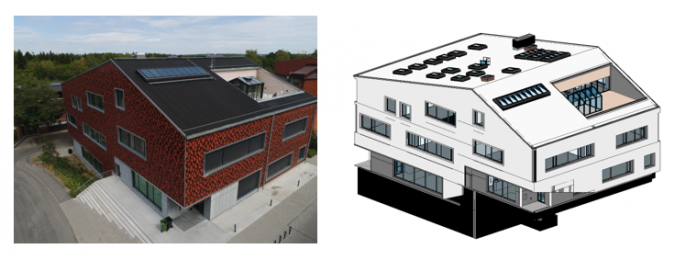
The measuring guidelines were used to extract geometric information of three buildings, including the educational building at KTH, Stockholm (Figure 2). Two people performed the geometric information extraction in parallel. The first person utilized 2D building footprints and airborne laser scanning (ALS) point clouds (point density: 12 points/m2). This input data was modelled using standard ALS methods and ETL tools to generate the geometric models. The second person used BIM as input data to other ETL processes to generate the models.
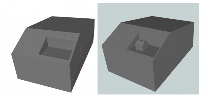
The resulting building models for the KTH building are shown in Figure 3. The relative geometric differences between the models are marginal, with RMS values in the size of a few decimetres in the horizontal plane and around one decimetre in the vertical dimension. Since the BIM models were not georeferenced, the absolute geometric differences could not be evaluated. One apparent difference between the generated models is that the model created from BIM data includes a greenhouse on the terrace. This greenhouse is not included in the model from ALS/footprint data, as the greenhouse is made of glass which results in a low number of points in the ALS data. Neither of the models represented the roof overhang at the entrance. ALS data is not capable of identifying such an overhang, and the person using BIM data lacked instructions in the measurement guidelines about how to handle roof overhangs.
The study confirmed that BIM models can potentially be used to update city models with new buildings. A main lesson learned is the need for good measurement guidelines that allow multiple data sources to be used.
Requesting BIM data on query level
In the previous study, BIM data was transformed into CityGML and integrated into the 3D city model. An alternative approach is to keep the BIM data and the city models in separate data repositories and create a common query interface instead. In this manner, an application can utilize both data sources. Integration on query level requires that the information models for the 3D city models and BIM data are interlinked. One plausible solution to achieve this is to create a knowledge graph (linked data) from the two data sources, where the respective ontologies are aligned. Knowledge graphs are increasingly used to break data silos in various domains, but are only sparsely exploited in GeoBIM, partly due to the difficulties in handling geometries in knowledge graphs. However, work is ongoing to define ontologies for 3D city models, e.g. based on the CityGML data schema, and ontologies in the BIM domain, such as ifcOWL and BOT.
Solar neighbourhood simulation is one application that requires both city models and BIM data. The modelled incoming solar radiation is used to estimate the indoor daylight comfort and also energy savings. Solar neighbourhood simulations require simplified building geometries that can be retrieved from city models, as well as window information, which is seldom presented in city models but can be extracted from BIM models. In order to evaluate the applicability of the knowledge graph approach, a case study was conducted with one building available as IFC model and converted to CityGML. Data from both sources was transformed into knowledge graphs based on their respective ontologies (CityGML and ifcOWL/BOT) and linked to the building instances using a commonly used vocabulary (Figure 4). The knowledge graphs were stored in an RDF store. The query interface partially utilized the OGC standard GeoSPARQL – an extension of the query language SPARQL. The system architecture enabled queries such as finding the total window area of the building and extracting the geometries of all the windows in the building.
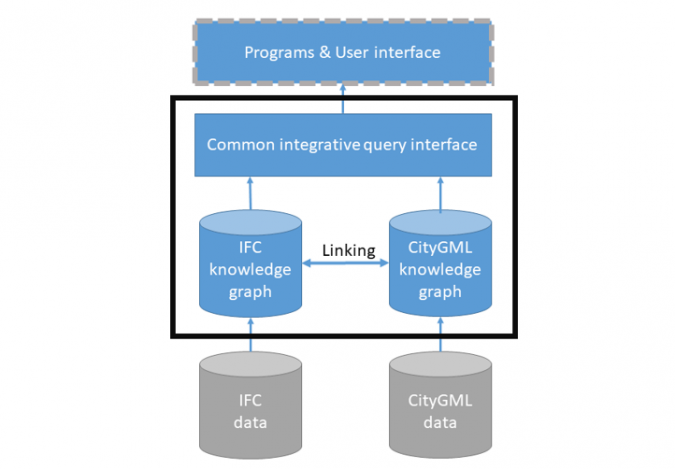
Several challenges remain before a common query interface to knowledge graphs can be used in a production environment. The ontologies have to be further developed and they should be interoperable and well aligned. This is one important theme of an ongoing cooperation between OGC (from the geospatial side) and BuildingSMART (from the BIM side). On the data level, there is a coordination challenge of defining responsibilities and practices in setting common IDs and handling them through the life cycle. From a technical perspective, it is challenging to develop efficient RDF stores for querying and storing the geometries of 3D data. Finally, from an end-user perspective, the support of knowledge graph (RDF) data from relevant programs is a prerequisite, i.e. they should ideally implement a SPARQL interface. Despite these challenges, the authors believe that the knowledge graph approach has great potential in GeoBIM.
Conclusions
This article has discussed the opportunities and challenges associated with utilizing BIM data together with city models. Experience has shown a large potential for utilizing BIM data in several applications to update and enrich city models. However, the technical solutions should be guided by a comprehensive understanding of the target applications.
Further reading
Noardo, F., Harrie, L., Arroyo Ohori, K., Biljecki, F., Ellul, C., Krijnen, T., Eriksson, H., Guler, D., Hintz, D., Jadidi, M.A., Pla, M., Sanchez, S., Soini, V.-P., Stouffs, R., Tekavec, J., and Stoter, J., 2020. Tools for BIM-GIS Integration (IFC Georeferencing and Conversions): Results from the GeoBIM Benchmark 2019. ISPRS Int. J. Geo-Inf., 9, 502. https://doi.org/10.3390/ijgi9090502
Sun J., Olsson P.-O. Eriksson H., and Harrie L., 2019. Evaluating the Geometric Aspects of Integrating BIM Data into City Models. Journal of Spatial Science. https://doi.org/10.1080/14498596.2019.1636722
Huang, W., Olsson P. O., Kanters J. and Harrie L., 2020. Reconciling city models with BIM in knowledge graphs: a feasibility study of data integration for solar energy simulation. ISPRS Annals of Photogrammetry, Remote Sensing and Spatial Information Sciences. 4/W1 ed. Copernicus Publications, Vol. 6. p. 93-99.

Value staying current with geomatics?
Stay on the map with our expertly curated newsletters.
We provide educational insights, industry updates, and inspiring stories to help you learn, grow, and reach your full potential in your field. Don't miss out - subscribe today and ensure you're always informed, educated, and inspired.
Choose your newsletter(s)


