

Elevating knowledge: read our in-depth features
Looking for a recipe for business success in surveying? Don't underestimate the importance of innovative surveying services, says Moritz Lauwiner. The latest measurement sensors and software, decades ...

In the rapidly evolving landscape of geospatial technology, the annual Trimble Dimensions gathering is a dependable beacon for the surveying and mapping fields, providing a panoramic view of the curre...

Intergeo 2023 was an electrifying three-day event in Berlin, transforming the city into the global geospatial capital. From 10-12 October, professionals from across the globe convened for the world’...

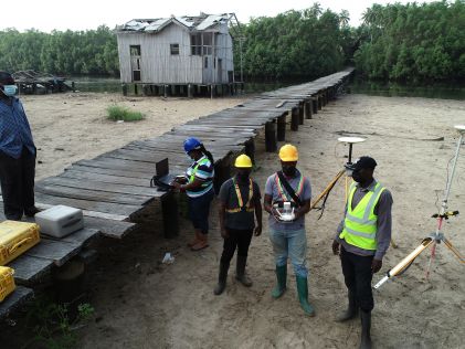
New knowledge and tools are needed if surveyors are to fulfil their critical role along the path to achieving humanity’s global climate goals related to land, water and the marine environment. Surve...

Thanks to the ability of digital twins to provide insights into the reality of present conditions and the impacts of future scenarios, they have the potential to revolutionize the planning and efficie...
In this exclusive interview, two of the driving forces behind this year's Intergeo talk about the event's evolution and impact, nurturing talent, land surveying, Earth observation and the Blue Economy...

GEO Business, the UK’s premier geospatial event, is celebrating its tenth anniversary when it returns to ExCeL London on 5 and 6 June 2024. This edition promises to be the most dynamic and comprehen...

The Faroese Environment Agency, responsible for national mapping activities including land mapping and hydrographic surveying, has recently joined EuroGeographics, the representative body for European...

The fourth edition of Geo Connect Asia (GCA), celebrated as the region's premier trade event and conference for the geospatial, positioning and remote sensing industries, truly delivered during its tw...

The Open Maps For Europe 2 (OME2) project has revealed plans to boost the utilization of European cadastral data. This includes efforts to enhance its discoverability and accessibility. As part of thi...

Geo Connect Asia (GCA) is set to return to the Sands Expo and Convention Centre in Singapore on 6 March and 7 March 2024. Since its establishment in 2019, GCA has become the premier trade event for th...

EuroGeographics is drawing attention to the indispensable role of official national geospatial data in enhancing Copernicus Services, particularly within land monitoring and emergency management. This...

Our weekly newsletter is an easy way to stay updated with our latest articles, news, and magazines. It's the easiest way to stay current with the industry.
Subscribe to our newsletter(s)A topographic survey collects information about the land's natural and man-made characteristics, as well as its terrain. Buildings, fences, trees, and waterways are permanent structures that accurately define the ground and its boundaries. The elevation of the terrain is depicted by land contours and spot levels. Architects, engineers, construction builders, and others utilize topographic maps to precisely visualize their sites and speed up development.
Architects, engineers, construction builders, and others utilize topographic maps to precisely visualize their sites and speed up development. These maps, a crucial part of land surveying, provide an accurate representation of all features, elevations, and contours of the land.
With this comprehensive understanding of a site, professionals can make informed decisions about design and construction plans, thereby ensuring efficiency and safety in their projects.
Topographic surveys, a significant aspect of land surveying, serve as a critical starting point in the design process. These surveys enable architects to understand the existing conditions of the site and how they might influence or be incorporated into their designs.
For example, the site's natural slope might lend itself to a particular building design or influence how rainwater drainage is handled. Trees and other existing features might be integrated into landscape design plans, or they might indicate areas where construction should be avoided to preserve local ecosystems.
Engineers also rely heavily on the detailed information provided by land surveying and topographic surveys. They use these surveys to analyze how the land will support structures and roads, assess potential flood risk, and plan drainage.
Further, topographic surveys aid in plotting the path of utilities and determining volumes for earthworks. Engineers can identify high and low points in the land that may impact the structural integrity of future developments, assess the impact of new construction on local water flow, and plan where utilities should go to avoid disruption to the land or other structures.
Construction builders turn to land surveying, specifically topographic surveys, to prepare the site for construction. These surveys provide the necessary data to plan the layout of structures, roads, and utilities, and calculate the quantities of materials needed for various phases of the project.
Moreover, topographic surveys allow builders to spot any potential challenges before construction begins. These may include steep slopes that might require extra safety measures, or areas of poor soil that might necessitate additional groundwork.
Moreover, topographic surveys, an essential element of land surveying, also play a significant role in legal and planning processes. They can be used to resolve land disputes or create legal descriptions of a property.
Equally, these surveys support applications for planning permission. A topographic survey provides a legally defensible basis to establish land boundaries, helping to prevent future disputes.
In essence, the detailed information gathered in a topographic survey helps bring a piece of land to life. This aspect of land surveying enables professionals across various sectors to visualize, plan, and execute their projects with precision.
As technology continues to evolve, advancements in surveying methods, such as drone technology and 3D scanning, continue to enhance the level of detail and accuracy in topographic surveys. This makes them an indispensable tool in today's construction and engineering projects.
This site uses cookies. By continuing to use this website, you agree to our Cookies Policy. Agree