

Elevating knowledge: read our in-depth features

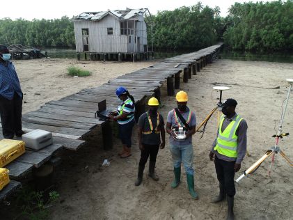
Israel’s national roads company is embarking on a large-scale, multi-year project to digitize its entire network. Surveying company Kav Medida has been awarded the contract to map the northern half ...

In the early days of surveying, surveyors were pioneers in charting the unknown. Today, with the Earth having been completely mapped to some degree, surveying has become a much more specialized field ...
From drones and satellites to airborne-based sensors and Lidar, advances in remote sensing and geospatial information science are driving the development of innovative methods for data acquisition, pr...

The city of Zagreb has been developing a semantic 3D city model since 2008. The city spatial planning sector was recognized as the main project user and developer, while more users were detected in th...

Population growth, urbanization and rapid digitalization all represent global challenges, but they also offer opportunities for the geospatial industry, because reality capture technology is an essent...

To find out more about the geomatics education situation across the globe, 'GIM International' spoke to several industry experts from academia around the world. Are the numbers of students in geomatic...

Emlid, the manufacturer of Reach GNSS receivers, has launched the Pix4D & Emlid Scanning kit. The kit combines advanced photogrammetry with RTK precision for quick data capture when documenting trench...

GEO Business, the UK’s premier geospatial event, has just released its highly anticipated programme for the 2024 edition, happening from 5-6 June at ExCeL London. This expo, free to attend, is tailo...

Smart Delta has entered into partnership with Cyvl.ai, combining mobile mapping experience with AI expertise. Smart Delta views this step as a powerful new opportunity to address challenges and discov...

Pix4D has launched PIX4Dcatch 2.0: a new and improved version of Pix4D’s terrestrial scanning iOS mobile app that adds professional-grade augmented reality (AR) and compatibility with a multitude of...

Plowman Craven has secured funding from the private equity firm Agathos. This significant investment will support the company in achieving its ambitious growth objectives on an international scale. Ac...

GEO Business, the UK’s premier geospatial event, is celebrating its tenth anniversary when it returns to ExCeL London on 5 and 6 June 2024. This edition promises to be the most dynamic and comprehen...

Our weekly newsletter is an easy way to stay updated with our latest articles, news, and magazines. It's the easiest way to stay current with the industry.
Subscribe to our newsletter(s)A topographic survey collects information about the land's natural and man-made characteristics, as well as its terrain. Buildings, fences, trees, and waterways are permanent structures that accurately define the ground and its boundaries. The elevation of the terrain is depicted by land contours and spot levels. Architects, engineers, construction builders, and others utilize topographic maps to precisely visualize their sites and speed up development.
Architects, engineers, construction builders, and others utilize topographic maps to precisely visualize their sites and speed up development. These maps, a crucial part of land surveying, provide an accurate representation of all features, elevations, and contours of the land.
With this comprehensive understanding of a site, professionals can make informed decisions about design and construction plans, thereby ensuring efficiency and safety in their projects.
Topographic surveys, a significant aspect of land surveying, serve as a critical starting point in the design process. These surveys enable architects to understand the existing conditions of the site and how they might influence or be incorporated into their designs.
For example, the site's natural slope might lend itself to a particular building design or influence how rainwater drainage is handled. Trees and other existing features might be integrated into landscape design plans, or they might indicate areas where construction should be avoided to preserve local ecosystems.
Engineers also rely heavily on the detailed information provided by land surveying and topographic surveys. They use these surveys to analyze how the land will support structures and roads, assess potential flood risk, and plan drainage.
Further, topographic surveys aid in plotting the path of utilities and determining volumes for earthworks. Engineers can identify high and low points in the land that may impact the structural integrity of future developments, assess the impact of new construction on local water flow, and plan where utilities should go to avoid disruption to the land or other structures.
Construction builders turn to land surveying, specifically topographic surveys, to prepare the site for construction. These surveys provide the necessary data to plan the layout of structures, roads, and utilities, and calculate the quantities of materials needed for various phases of the project.
Moreover, topographic surveys allow builders to spot any potential challenges before construction begins. These may include steep slopes that might require extra safety measures, or areas of poor soil that might necessitate additional groundwork.
Moreover, topographic surveys, an essential element of land surveying, also play a significant role in legal and planning processes. They can be used to resolve land disputes or create legal descriptions of a property.
Equally, these surveys support applications for planning permission. A topographic survey provides a legally defensible basis to establish land boundaries, helping to prevent future disputes.
In essence, the detailed information gathered in a topographic survey helps bring a piece of land to life. This aspect of land surveying enables professionals across various sectors to visualize, plan, and execute their projects with precision.
As technology continues to evolve, advancements in surveying methods, such as drone technology and 3D scanning, continue to enhance the level of detail and accuracy in topographic surveys. This makes them an indispensable tool in today's construction and engineering projects.
This site uses cookies. By continuing to use this website, you agree to our Cookies Policy. Agree