Digitizing Israel’s road network with high-end geospatial technology
Advancing towards autonomous vehicles
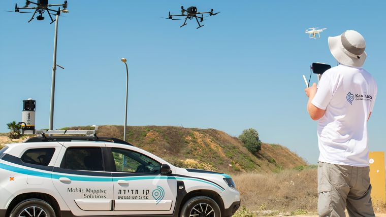
Israel’s national roads company is embarking on a large-scale, multi-year project to digitize its entire network. Surveying company Kav Medida has been awarded the contract to map the northern half of the network using advanced GIS software, UAVs and 360° mobile mapping cameras. The resulting digitized maps will significantly improve the accuracy and efficiency of road maintenance and monitoring in Israel, providing detailed measurements related to lighting pole arm lengths, sign heights, traffic sign azimuth, ditch type and cross-section depths. This article provides a closer look at how geospatial data is being captured and utilized, and how the company has implemented innovative solutions to enhance productivity while simultaneously reducing operational costs.
Like many modern countries, Israel is continuously improving its transportation infrastructure. Netivei Israel, the national roads company of Israel, is currently modernizing the maps of its intricate network of roads. Netivei Israel manages 90% of Israel’s roadways from the planning and building stages through to maintenance. Due to the dynamic nature of the 8,500km road network and Israel’s burgeoning population creating an ever-increasing demand for new, well-managed roads, Netivei Israel decided to embark on an ambitious multi-year GIS-based project to digitize its entire road infrastructure. Kav Medida, a prominent survey company in Israel, has been awarded a contract to map the northern half of Israel’s roadways in this largest project of its kind. It is utilizing Esri’s ArcGIS Pro to create digitized maps with precise accuracy, and mainly using open-source QGIS with self-developed customized tools. Through the use of orthophoto, aerial imaging, ground-based 360° mobile mapping and – in rarer cases – on-site field observations, precise measurements and detailed data about roadway features produce high-resolution digitized maps.
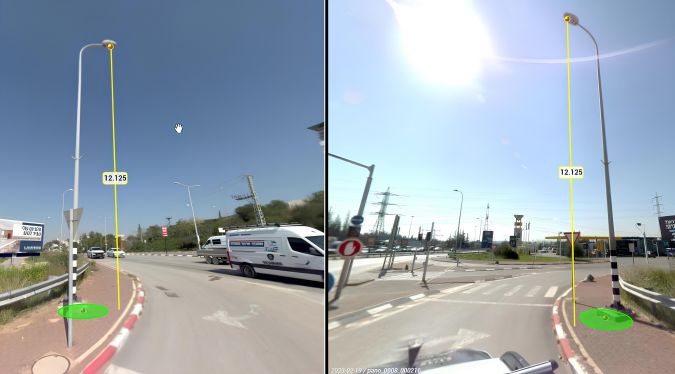
Using an advanced GIS-based methodology, the current GIS system will be upgraded to drastically improve the accuracy and efficiency of road maintenance and monitoring in Israel. The level of map detail is unprecedented in Israel. For example, there are detailed measurements relating to lighting pole arm lengths, heights of signs above roadways, azimuth of traffic signs, ditch type and depths at various cross-sections, to name but a few examples. These detailed maps will undoubtedly pave the way for the future of autonomous vehicles on Israel’s roads.

GIS road mapping
Starting in 2021, Netivei Israel initiated a massive undertaking to map all of its roads using advanced geographic information system (GIS) methodologies. This is a significant development that has the potential to revolutionize how roads are monitored and maintained, as it will be fully integrated into Netivei Israel’s existing GIS system. This undertaking is expected to have a profound impact on the efficiency and safety of Israel’s transportation network.
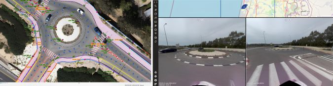
The project involves delivering 200km of mapped roads per month while ensuring strict quality assurance (QA) standards and several supervisory controls. Each batch of deliverables will include a geographic database (Esri GDB) comprising 37 feature layers such as lighting poles, paint strips, bus stops, traffic signs and more. Additionally, two sets of maps (orthophoto and non-orthophoto) in PDF format will be provided, with each section of roadway divided by index based on pre-defined cartographic parameters. Each batch will have indexes mapped based on three categories of scale, namely 1:250 (intersection), 1:500 (interchange), and 1:1,250 (freeway). Finally, panoramic (360°) images will be delivered through a link to a web application.
The project presents various obstacles for the land surveyors, such as adapting to a GIS environment instead of the more familiar DWG/DGN CAD software, meeting demanding production requirements, mapping areas with limited visibility, and operating in GPS-restricted or security zones. Despite these challenges, the team must prioritize maintaining project accuracy within established parameters to ensure its overall success. Kav Medida’s methodology was developed to bring consistent and reliable long-term results. This methodology consists of three areas: data collection, digitization & classification, and data distribution.
Geospatial data handling
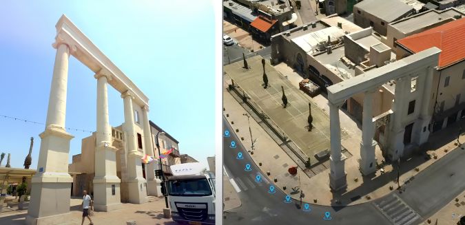
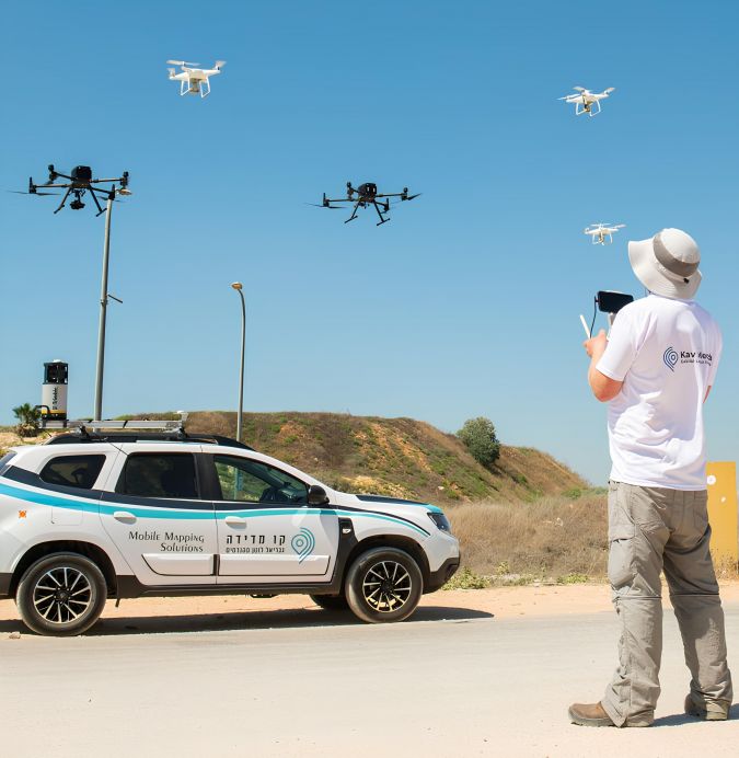
For data collection, two main mapping devices are employed: unmanned aerial vehicles (UAVs or ‘drones’) and 360° mobile mapping photogrammetric cameras. When used together, these advanced technologies have an overlap of 80%, enabling mapping of 95% of the total features without requiring on-site field assessments. This approach results in cost savings, more precise measurements and faster output.
To ensure consistent geographic positioning with both devices, the same ground control points (GCPs) are established as benchmarks for georeferencing, with one GCP set for every 500 metres. Once all the data is captured and processed, the mapping work can start in the office. Ten GIS operators begin the task of sectionalizing the data into chunks, while the GIS manager oversees the assignments for each team member. Each operator works within their own area of expertise, e.g. data arrangement, digitization, classification, QA, etc.
Although the project is well managed, there are limitations to the workflow in the form of parallel work limitations. Mapping with proprietary GIS software is restricted when multiple users are utilizing the same geodatabase simultaneously. To solve this, QGIS was used to build a server environment to control all the work conducted by the operators. More specifically, the solution consists of a server that can monitor and build the GDB on the fly, while automatically producing many more insights. These insights include: which layer was mapped by which operator, where the weak link is in the QA process, which layer consumes more time per operator, GDB list errors, and more. QGIS has proved to be more cost-effective since it is an open-source application with no licence fees and no limit to the project’s team size. In fact, this unique server method enabled the GIS team to work from home during the COVID-19 lockdowns, which also allowed specialized talent to be hired from overseas. On top of all this, Orbit (3D mobile mapping software) built a QGIS plugin so that all the aerial imagery can be streamlined to the working environment.
The key role of UAV-based mapping
One of the aims of the project is to minimize post-production labour. In order to achieve this, advanced equipment like the reliable DJI Phantom 4 RTK is used for a more comfortable photogrammetric process. Flight routes are set to a nadir (vertical) configuration with a forward and side overlap of 80% between images. The UAV’s flight paths are arranged to follow terrain so that it stays within the nominal range of Israel’s entire SRTM topographic elevation database. Advanced UAV data processing is comprised of aerotriangulation of the image block, to then create true orthophotos to a resolution of 1.5cm/pixel. The need for creating true orthophotos rather than standard orthophotos is mainly due to digitization requirements which require that tall objects like bus stations are digitized with absolute 2D accuracy.
When producing 200km worth of high-resolution true orthophoto images per month, one of the challenges is the need for high-performance computer processing. For this purpose, a network clustering of advanced personal computers was installed at Kav Medida’s headquarters in Herzliya and has been running 24/7 since the project’s inception. The processing is mostly automated via Python scripting for orthomosaic and product exportation phases. There are additional sub-products like digital surface models (DSMs), and a variety of external orientation files that can be used for stereo mapping systems for additional extraction and 3D meshing.
Data distribution
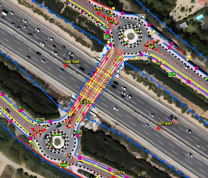
Once all the GIS digitization is completed, the data is then delivered to the client and the external QA team. Given the extensive breadth of the project, the data comprises tens of terabytes from both UAV and mobile mapping cameras, GIS databases, orthophoto and DSM files, and ground control points. By using a published mobile mapping interface, all users can access any portion of any road from both a mobile and an aerial angle of view. Moreover, the end-user can utilize the built-in photogrammetric tools to measure, test and check all files via an internet browser. The final step is creating the PDF cartographic map, of which 60% is done automatically by using ArcGIS Pro. See the figure below for a sample index generated in PDF format on a 1:250 scale.
The future of road transportation
In addition to serving Netivei Israel’s own purposes, the more precise and complete maps can be utilized by autonomous vehicle companies to help drive autonomous vehicle technologies. These prebuilt maps will serve as their baseline and – in conjunction with active Lidar, radar, sensors, cameras, GPS and machine learning – these supporting technologies will aid autonomous vehicles in navigating and continuously improving their traffic performance over time. Autonomous vehicle companies will integrate on-the-fly data into their autonomous vehicles’ geodatabase using online push updates.
Looking to the future, timely and accurate data will be increasingly critical to many facets of Israel’s infrastructure, especially with the advent of smart cities. One such critical facet to the Internet of Things is the implementation of autonomous vehicles on the road, where real-time data will be necessary and paramount, both with vehicle and road data. Detailed maps are one component of this. Vehicles will be able to communicate data to each other in real time, and process that data by utilizing machine learning with the use of advancements in artificial intelligence (AI).
Conclusions
Israel is paving the way for advanced mapping methodologies by leveraging cutting-edge technology. With the ever-increasing accuracy of road mapping, maintenance can be carried out more efficiently and with greater precision. Technological advancements in mapping and surveying have been greatly accelerated by Israel’s expertise in storing and processing surveying and mapping data using digital information systems. Israel’s leadership in AI and machine learning has also facilitated the swift transition from traditional technologies to modern, advanced solutions, meeting the rising demands of the industry. This will result in more accurate maps, which in turn will aid the proliferation of autonomous vehicles, as road features can be input with greater detail and accuracy. The future of mapping is indeed exciting, but it also poses new challenges.

Value staying current with geomatics?
Stay on the map with our expertly curated newsletters.
We provide educational insights, industry updates, and inspiring stories to help you learn, grow, and reach your full potential in your field. Don't miss out - subscribe today and ensure you're always informed, educated, and inspired.
Choose your newsletter(s)


