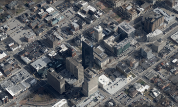
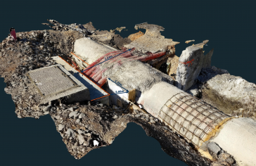
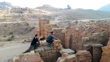
• About us
  • Contact
  • Advertise
  • Join our newsletter
  • Product Showcase
GIM International
  • Topics
    • Land surveying
    • Cartography / GIS
    • Remote sensing
    • Positioning
    • Urban planning
    • Construction & Engineering
    • Lidar
  • Articles
  • News
  • Case studies
  • Members
  • Events
  • Videos
  • Magazine
  • Podcast
GIM International
  • Mapping the world
  • ›
  • Themes
  • ›
  • Mobile Mapping

Mobile Mapping

Collecting geospatial data from a moving platform is known as mobile mapping. Mobile mapping systems are often equipped with a variety of photographic, radar, Lidar or other types of remote sensing systems. GIM International has picked a selection of the best mobile mapping stories, ranging from mobile mapping using cars to other platforms such as a backpack.

Hexagon’s SIG division set to form the core of new company Octave
business news

Hexagon’s SIG division set to form the core of new company Octave

June 17, 2025

At its global event Hexagon Live, held in Las Vegas, the company announced plans to spin off several key business units – including the Safety, Infrastructure & Geospatial (SIG) division – into a ...

Read more→
Leica Geosystems integrates Sony’s IMX811 sensor into TerrainMapper-3 system
aerial mapping

Leica Geosystems integrates Sony’s IMX811 sensor into TerrainMapper-3 system

June 17, 2025

Leica Geosystems has integrated Sony’s latest IMX811 sensor into the Leica TerrainMapper-3 topographic Lidar system – enhancing the system’s image collection capabilities. This development is ma...

Read more→
EuroGeographics marks 25th anniversary with record-breaking gathering of geospatial leaders
geoinformation

EuroGeographics marks 25th anniversary with record-breaking gathering of geospatial leaders

June 17, 2025

Leaders from 47 European National Mapping, Cadastral and Land Registration Authorities recently met in Latvia to exchange insights on delivering authoritative data in increasingly uncertain times. Hos...

Read more→
SFL Missions to support ESA’s Moon mapping study
digital elevation model

SFL Missions to support ESA’s Moon mapping study

June 12, 2025

SFL Missions is involved in the European Space Agency’s Moonraker lunar mapping mission to create a detailed elevation map of the Moon’s surface. The company is part of a team led by NUVIEW GmbH t...

Read more→
Why your GIS skills are more relevant than ever
spatial intelligence

Why your GIS skills are more relevant than ever

June 12, 2025

The global GIS market is predicted to grow by over 13% through 2025 and beyond, reflecting the evolution of spatial intelligence into a foundational layer of modern operational and strategic decision-...

Read more→
Where space exploration meets geospatial: a growing connection
space

Where space exploration meets geospatial: a growing connection

June 12, 2025

Leveraging satellite imagery, Earth observation is a prime example of where the geospatial field intersects with the space exploration industry. This point of intersection is currently where the great...

Read more→
CyArk unveils virtual Mount Rushmore experience with new insights
cultural heritage

CyArk unveils virtual Mount Rushmore experience with new insights

June 12, 2025

CyArk has launched a new virtual experience of the Mount Rushmore National Memorial in the USA. This immersive experience offers fresh visual perspectives of the monument and brings together its engin...

Read more→
Canadian space firm PCI Geomatics expands operations in Scotland
earth observation

Canadian space firm PCI Geomatics expands operations in Scotland

June 11, 2025

PCI Geomatics (doing business as Catalyst) has chosen the Scottish city of Edinburgh as the latest hub in its ongoing global expansion. The new office, located at the Futures Institute, reinforces PCI...

Read more→
New guide for smarter geospatial survey procurement published in UK
land surveying

New guide for smarter geospatial survey procurement published in UK

June 11, 2025

A new publication titled ‘Do You Need a Survey?’ has been released to help professionals across the United Kingdom’s built and natural environment sectors make informed choices when procuring ge...

Read more→
Geospatial law, ethics & the edge of innovation: a conversation with Kevin Pomfret podcast
geospatial

Geospatial law, ethics & the edge of innovation: a conversation with Kevin Pomfret

June 10, 2025

In this eye-opening episode of Mapping the Conversations,host Dr. Valrie Grant sits down with Kevin Pomfret, a leading voice in geospatial law, policy, and ethics. Kevin, a partner at Williams Mullen ...

Read more→
German government renews partnership with Planet for satellite-based environmental insights
earth observation

German government renews partnership with Planet for satellite-based environmental insights

June 6, 2025

Planet Labs, a leading provider of daily satellite imagery and Earth observation insights, today announced that the German Federal Ministry of the Interior and Community (BMI) and the Federal Agency f...

Read more→
YellowScan and Argosdyne expand reach with certified Lidar drone solution
aerial mapping

YellowScan and Argosdyne expand reach with certified Lidar drone solution

June 6, 2025

YellowScan, a global provider of UAV Lidar solutions, has teamed up with drone manufacturer Argosdyne in a strategic partnership focused on the EasyMapper drone series, which has now been officially a...

Read more→
Countdown to Intergeo 2025: innovation meets application
geospatial community

Countdown to Intergeo 2025: innovation meets application

June 4, 2025

From 7-9 October, Frankfurt will be the hub for all professionals turning geodata into real-world impact. At Intergeo 2025, innovation meets application – where the future of digital infrastructure,...

Read more→
Laser-aided INS advances dead-reckoning accuracy in GNSS-denied environments
navigation

Laser-aided INS advances dead-reckoning accuracy in GNSS-denied environments

June 4, 2025

Advanced Navigation has successfully demonstrated a hybrid solution for long endurance GNSS-denied navigation, proving that a software-fused inertial-centred architecture is the defining standard for ...

Read more→
Earth observation sensors and technology: the current state of play
satellite remote sensing

Earth observation sensors and technology: the current state of play

June 4, 2025

By offering the ability to track wildfires, flooding, land use, infrastructure and urban development, satellite imagery fuels smarter geospatial analysis for planning, risk assessment and environmenta...

Read more→
  • ←Prev
  • 1
  • 2
  • 3
  • 4
  • 5
  • Next→
GIM International
Geomares
GIM International is the independent and high-quality information source for everything the global geomatics industry has to offer, online and offline! We provide information about all the major topics in the business, such as mapping & surveying, geodesy, cartography, Lidar, GIS, photogrammetry, UAV/UAS, GNSS, remote sensing and more.

Themes

  • Lidar
  • GIS
  • UAS/UAV
  • GPS
  • GNSS
  • Mobile Mapping
  • Point Clouds

General

  • Advertise
  • About us
  • Contact
  • Contribute
  • Industry Showcase

Follow GIM

  • Newsletter
  • Facebook
  • LinkedIn
  • Twitter
  • News RSS Feed
  • Articles RSS Feed
  • Privacy
  • Cookies
  • Terms & Conditions
  • Sitemap
  • Contact
  • Advertise

© 2025 Geomares. Copyright reserved.

GIM International
  • Topics
    • Land surveying
    • Cartography / GIS
    • Remote sensing
    • Positioning
    • Urban planning
    • Construction & Engineering
    • Lidar
  • Articles
  • News
  • Case studies
  • Members
  • Events
  • Videos
  • Magazine
  • Podcast

This site uses cookies. By continuing to use this website, you agree to our Cookies Policy. Agree