Navigating the geospatial frontier
Preview of Intergeo 2023
In this exclusive interview, two of the driving forces behind this year's Intergeo talk about the event's evolution and impact, nurturing talent, land surveying, Earth observation and the Blue Economy.
To unite the global geospatial community yet again, this year Intergeo is returning to Berlin, Germany, from 10 to 12 October. GIM International had the privilege of speaking with two of the driving forces behind Intergeo: Christiane Salbach, managing director of the German Association for Geodesy, Geoinformation and Land Management (DVW), and Rudolf Staiger, president of DVW. In this interview, they talk about the evolution of the event and its profound impact on the geospatial industry, as well as the firm commitment to nurturing emerging talent. The discussion also encompasses the evolving landscape of land surveying, the immense importance of Earth observation and the promising influence of the Blue Economy.
To what extent has Intergeo changed over the years?
Salbach: Intergeo has evolved continuously since the inaugural edition in 1995 in Dortmund. Today, it is unquestionably the world’s leading trade fair for geodesy, geoinformation and land management. Conceptually, Intergeo has always integrated new thematic fields that extend beyond the realm of geoinformation. Some years ago, for example, it incorporated areas such as BIM (building information modelling, Ed.), UAVs (uncrewed aerial vehicles or ‘drones’, Ed.) and laser scanning. This year, the focus is on the maritime economy and Earth observation, where we see significant growth potential both for exhibitors and for applications in the future. Cross-cutting technologies like digitalization and AI (artificial intelligence, Ed.) are crucial dynamic factors in the data-driven geospatial industry.
Staiger: While the COVID-19 situation somewhat slowed the steady increase in internationalization over the past three years, it’s already evident that Intergeo in Berlin will see an increase in international exhibitors and visitors.
The domain of geospatial technology has experienced notable expansion. How is this growth reflected on the exhibition floor and within the conference programme?
Staiger: The expansion is primarily based on the fact that not only neighbouring disciplines require or handle geospatial data; today, hardly any application can function without georeferencing. The relationships have become much more complex – everything is interconnected, and georeferencing is the linking element. Additionally, data acquisition has fundamentally changed. While measurements used to be localized, today it’s about processing and interpreting big data – often using AI – to produce results. The capabilities of processing big data, including the storage of large datasets with external access by various users, continually opens up new application fields – and not just for specialists. Urban digital twins are a prime example of this, as is citizen participation.
Salbach: The instruments and diverse software applications showcased by exhibitors are not only interesting for the geo industry, but also for infrastructure operators in the mobility, energy and planning sectors. The target audience is expanding, and Intergeo’s offerings are growing too. The general public recognizes that geodata, as well as location-based data, is part of the essential infrastructure for modern society, now and in the future. Challenges like climate change can only be tackled with geodata. The work of geospatial engineers is visible, acknowledged and valued across the industry, and this is prominently represented in the conference. Topics like smart cities, BIM, Earth observation, sustainability in real estate, modern land management, and cartography-related issues are discussed. The future-focused themes of official geoinformation management, 3D point cloud handling and the use of AI for sustainable applications also receive special attention.
How is Intergeo showcasing its commitment to supporting the search for new geospatial talent?
Staiger: At DVW, we are well aware of the need for young professionals in the geospatial field. We recognize that not only the industry, but also research and education, public administration and freelance professions are facing immense challenges in this regard. Together with our sister organisations BDVI and VDV, DVW is supporting the two campaigns called Weltvermesserer and Arbeitsplatz Erde which are aimed at introducing geospatial to young people as an attractive and forward-looking profession. The Weltvermesserer campaign also promotes the opportunity for those who are interested to visit Intergeo and immerse themselves in the world of geoinformation.
Salbach: Furthermore, Intergeo has been facilitating the Geoinnovation Campus for years, where universities and colleges can present themselves to an interested young audience. This year’s event in Berlin will be no exception and we’re expecting a lot of activity again, especially on Thursday 12 October when the Intergeo School Day is expected to attract more than 70 students. Additionally, the stages provide an exclusive platform. On the Wednesday, ten students will present their bachelor’s and master’s theses to the audience in the form of elevator pitches. The best three will be honoured with the Intergeo Geoinnovation Award, which comes with prize money totalling €1,000. And on the Tuesday, experts will discuss their best-practice solutions for recruiting young professionals, because there’s no point in everyone reinventing the wheel; learning from the best is allowed and encouraged.
Which particular aspects are you looking forward to the most?
Salbach: We are hoping for a regular Intergeo that is no longer influenced by the COVID-19 restrictions. Last year in Essen, although there was a strong sense of optimism among the participants, the pandemic situation was still very top of mind. But now, despite the ongoing trend of reduced business travel triggered by the pandemic, it doesn’t seem to be affecting Intergeo. We’re delighted that the exhibition space in the Expo is almost fully booked at this time, and the registration numbers for the conference are very promising as well. The diverse and appealing programme, featuring numerous panel discussions on current topics, clearly caters to the needs of the geo community.
Staiger: In terms of content, the focus is naturally on the newly developed or expanded thematic areas. The BIM Area, the Earth Observation section, the Blue Economy and, of course, the new Unmanned Systems offering, which is a paid-content format that has been seamlessly integrated into the Expo. We are eager to see how the visitors will respond to these additional, specialized thematic offerings.
As the land surveying industry continues to transform, how is Intergeo proactively addressing the demand for new skillsets?
Salbach: Geodata authorities are evolving from data collectors to service providers for geo-related enquiries. One essential development is the utilization of remote sensing, particularly the data from the European Copernicus programme. This opens up entirely new applications and products. Optical sensors and radar also play central roles. Everything is related to geodata management and addressing societal issues. Digital twins are also worth mentioning in this context. These aspects will be especially highlighted on the Tuesday.
Does the incorporation of a dedicated segment for Earth observation at this year’s edition of Intergeo signal a shift towards greater emphasis on this aspect?
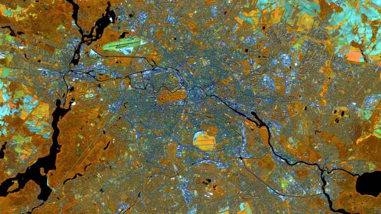
Salbach: The Earth Observation segment is not intended to be a one-time initiative this year, but rather the beginning of the development of a new thematic area. The significance of Earth observation data for documentation, as well as for simulating the impacts of climate change, deforestation and urban sprawl, has grown significantly in recent years. Both the conference – featuring a high-profile thematic track on Earth observation, including political aspects, on Tuesday 10 October – and the Expo, with the Earth Observation Area, will comprehensively address the topic of global monitoring. The political importance of this theme is underscored in the conference by the participation of speakers from the European Space Agency (Juliette Lambin), the EU Commission (Elisabeth Hamdouch) and the German federal government (Dr Anna Christmann).

Staiger: Global monitoring provides Earth observation data that allow us to grasp, understand and ultimately counteract local interconnections in a timely manner. Satellite data is already being employed in geoinformation management. The use of AI will further multiply the possible applications, and these will be the focal points of the first day of the conference. I see significant potential to establish Intergeo as a leading international trade fair and congress for Earth observation, thereby strengthening Europe’s – and particularly Germany’s – position in the Earth observation industry.
Which other prominent areas or topics will receive special emphasis during the 2023 event?
Salbach: The drone market is steadily gaining momentum as it grows and further professionalizes. Therefore, we are introducing the Unmanned Systems thematic complex for the first time as a paid-content format in the Expo, offering presentations on workflows, applications and value creation related to unmanned operations. Intergeo 2023 thus provides a unique and high-quality platform for companies, academics and decision-makers to network and stay informed about the latest developments and applications of unmanned systems.
Staiger: The Blue Economy will be another prominent feature this year. With the goal of establishing the foundations for the sustainable protection of the oceans, the United Nations has declared 2021 to 2030 to be the ‘Decade of Ocean Science for Sustainable Development’. Additionally, with the adoption of the High Seas Treaty in June 2023, the international community agreed to better safeguard the world’s oceans. All this means that the Blue Economy is becoming increasingly important. The collection, processing and provision of maritime geodata holds special significance for our habitat, especially in terms of ecological and energy-related issues, so once again, Intergeo is expanding its offerings in this domain.
Considering today’s technological possibilities, why do you believe it is necessary for geospatial experts from across the globe to gather at a meeting hub like Intergeo?
Salbach: Innovation thrives on the exchange of knowledge, experiences and ideas among experts. The best and most innovative ideas don’t arise from isolating oneself and contemplating in solitude, but rather from networking, drawing inspiration from new technologies and product innovations, understanding the needs of customers and users or directly enquiring about them, and integrating one’s solutions within a broader context. This is the motto of Intergeo – and not just since this year: “Inspiration for a smarter world”. In this spirit, allow yourself to be inspired as well. Visit Intergeo and become a part of the extensive geo network.
About Christiane Salbach and Rudolf Staiger
Christiane Salbach is managing director of DVW GmbH, responsible for the organization and management of Intergeo with a focus is on the implementation of the congress. Previously, she was responsible for the organization and management of the association’s general activities, including in coordination with the 13 German national associations.
Prof Rudolf Staiger has been president of DVW since January 2023, having previously held various positions at DVW including heading the former Working Group on Surveying Instruments and Methods until 2010. He served as president of the International Federation of Surveyors (FIG) from 2019-2022.


Value staying current with geomatics?
Stay on the map with our expertly curated newsletters.
We provide educational insights, industry updates, and inspiring stories to help you learn, grow, and reach your full potential in your field. Don't miss out - subscribe today and ensure you're always informed, educated, and inspired.
Choose your newsletter(s)


