
Mobile app to accelerate land administration in Indonesia
Combining data from smartphones, geodetic sensors and external databases
A mobile app has been developed to improve the success of cadastral survey implementation in Indonesia. The country has set itself ambitious land registration targets by 2025. The national cadastral survey app called Survey Tanahku (‘My Land Survey’) is connected to external sensors for geodetic measurements and also to civil registry services. This solution turns cadastral survey from costly and inefficient into efficient and affordable.
In Indonesia, land registration is a national priority. The aim is to certify all unregistered land parcels and validate the quality of previously registered parcels before 2025. Complete and efficient land registration and land-information services are critical to achieving the Sustainable Development Goals and improving the ease of doing business. Efforts on this front rely heavily on the success of cadastral survey implementation.
Traditional cadastral surveys require cadastral officers or licensed surveyors to conduct field visits for a boundary survey related to ownership documentation. They use geodetic instruments such as global navigation satellite system (GNSS) receivers. Ownership documentation is manually collected on paper. This is validated by documenting the agreement between the landowner and the owners of neighbouring parcels on their common boundary. Such activities require different kinds of media for data storage as well as different data collectors. It is a time-consuming and inefficient process.
Cadastral survey app
Smartphones are increasingly being used to collect data, either through dedicated apps or open-source apps such as OpenDataKit (ODK) and KoBoToolbox. However, the development of mobile data collection for land administration has been sporadic. A systematic land registration campaign is usually conducted by different teams (e.g. socialization, legal data collection, spatial data collection and verification teams). It is therefore difficult to achieve seamless data processing and integration. As a result, data standardization and data usability challenges arise in integrating spatial and legal data for either first titling or data maintenance.
The national cadastral survey app called Survey Tanahku (‘My Land Survey’) is an answer to these problems. Survey Tanahku is a smartphone app that provides cadastral mapping services based on a connection to external sensors for geodetic measurements. It also has a connection to civil registry services. Together, these turn cadastral survey from costly and inefficient into efficient and affordable.
The app allows data to be entered from both national cadastral databases (connected through land management services known as KKP services) and surveyors’ devices. If data on a new parcel is generated from a surveyor’s device, the boundary and land parcel attributes are stored locally as database records of GeoPackage, an SQLite container suitable for a geospatial mobile app. GeoPackage uses well-known binaries (WKBs) for storing geometries and raster data in the form of images/tiles and text (e.g. JavaScript Object Notation/JSON and National Marine Electronics Association/NMEA). The app is designed to support data transfer and mapping flexibility across different databases for surveyors in the field. Thus, it provides users with a secure single sign-on and authentication that is integrated with the national land information system (known as KKP). This setting allows account management and the linking of different databases without revealing user credentials.
Compliant with LADM standards
Since data collection with the app is aligned with the Land Administration Domain Model (LADM) standards, a survey mission can be completed quickly and efficiently. A mission involves collecting or verifying three important components: subjects (or party, e.g. claimants, neighbouring landowners, surveyors), objects (or land boundaries) and their subject-object relationships (or right-restriction responsibilities implied to party over spatial unit). The app makes these activities straightforward and efficient in the field, including by displaying online land records and boundaries stored in national cadastral databases. After completing a survey mission, the surveyor simply uploads the survey data into the survey dashboard.
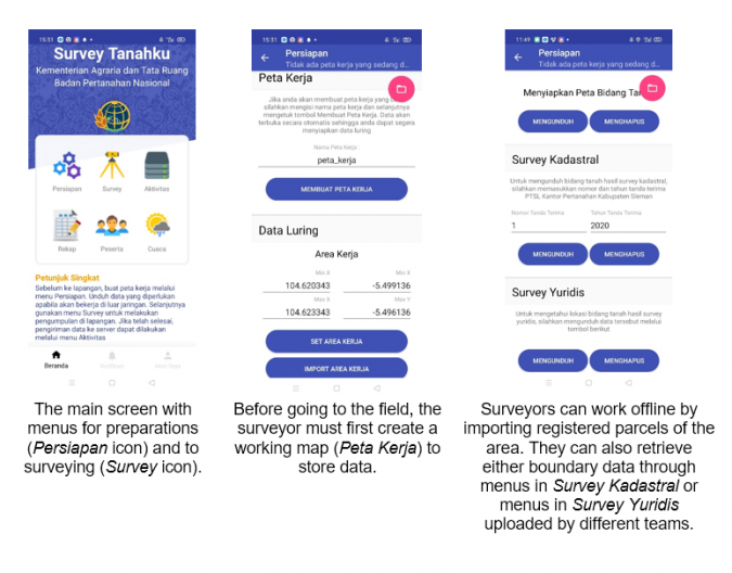
Survey preparations
Land surveyors prepare for a survey based on the following four steps:
- Prepare a working map by defining an area of interest, either drawing it by hand or specifying coordinates
- Import parcel maps from national cadastral databases (anticipating a weak internet connection in the field)
- Upload imagery and orthomosaics (prepared as tiles and stored locally) into the app in the form of image tiles, or as an image (which will then be prepared automatically as standard tiles by GeoPackage)
- Turn on the tracking tool to store details of the field visit (Figure 1).
Cadastral surveys
To create new land boundaries, points have to be created on the map canvas. Polygon points can be made by drawing on the map canvas (by selecting the ’Add a new parcel’ option) or via GNSS survey (by selecting the ’Connect to GPS via Bluetooth’ option) (Figure 2). The second option allows the mobile app to connect to an external GNSS receiver through Bluetooth. This helps store precise coordinates of boundary points agreed on by the claimants/landowners and neighboring landowners. NMEA-format data transfers the fixed coordinates gathered from the receiver to the app. During the measurement, if necessary and agreed to by the participants, the surveyor can also simply snap to existing boundary corner points. Once this process is done, the new surveyed land parcel is drawn on the mobile app. Participants can verify the position and edges of the new parcel against the surrounding land parcels. If the survey does not require measurements with a survey-grade GNSS device, the default method is to use the internal GNSS sensor unit in the mobile device. After creating points, surveyors can connect them or snap to existing points, lines or polygons in order to create a new parcel.
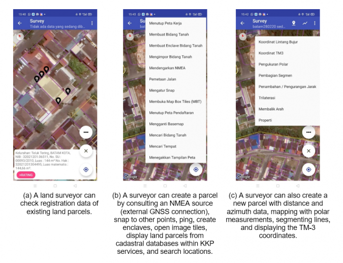
External databases
The mobile app can connect with external cadastral databases and civil registry databases. The surveyor can request Web Map Service (WMS) data from cadastral databases within the KKP services to load an official cadastral map, showing registered land parcels with registration status attributes. This is an important feature to avoid redundant boundary demarcation and to assess whether overlapping spatial representation is likely if a new land parcel is created. Attribute information on registration data can only be retrieved online.
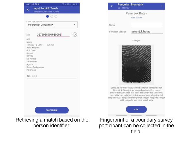
Every resident’s fingerprints are on their national identity card, which is entered into the civil registry databases maintained by the Civil Registration Directorate, Ministry of Home Affairs. This allows for efficient in-person validation for first land titling and in-field title validation for missing parcels.
Fingerprint reader
Either biometric-data or person-identifier queries can be used to search the national civil registry databases. In the Survey Tanahku app, biometric data is typically collected using a fingerprint reader connected via Bluetooth (Figure 3). The reader stores the fingerprint data and, when an internet connection is available, a query is sent to the server to verify the person’s identity from the civil registry databases. This biometric data collection includes fingerprints of claimants and adjacent landowners during field measurements for first land registration activities. It is then matched against civil registry databases. Supporting documents such as tax invoices, notarial deeds or letters of statement of land occupation provided by claimants can be annotated and photographed to be stored locally.
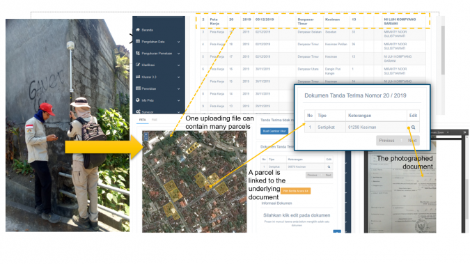
Uploading
When there is a strong internet connection, the party, subject, spatial and documentation data for every parcel is uploaded automatically. If the internet connection in the survey area is weak, uploads to a survey dashboard are delayed until a stronger connection is available. A centralized survey dashboard enables users to download geometries of land boundaries and document sources or images related to first or forensic titling (solving missing parcels). Once the survey data is sent to the survey dashboard, office validation can be done by registration officers. If the field data within the survey dashboard is accepted, field data can be integrated into the cadastral databases within KKP services in the final stage.
Supporting traditional surveys
If a GNSS measurement campaign is not possible for any technical or non-technical reasons (e.g. multipath challenges), the mobile app can facilitate measurements using distances and azimuth angles and distances. These can be handy for surveyors collecting data using tapes or laser-based distance measurers under intensive urban canopies in densely built environments. Where high-resolution satellite or drone images are available as orthomosaics, these can be imported into the app to facilitate general boundaries for community parcel mapping, usually applied for a fit-for-purpose land-administration campaign. This is especially useful for cadastral surveys in large rural parcels, when GNSS and distance measurements are inefficient. As long as claimants and boundary landowners agree, mapping can be done on top of the orthomosaics using mapping tools (snapping, drawing points/lines and creating a polygon).
Missing parcels
Government surveyors can use the mobile app to identify land parcels in the survey area not depicted in the cadastral map. Based on textual ownership data registered in the title and other related data (e.g. property tax invoices), surveyors can conduct interviews with community leaders and occupants to collect information regarding missing parcels. This activity is referred to as forensic titling, tracing and tracking. Where ownership proof can be provided, the document can be photographed and the boundary survey can be validated. If necessary, video or voice recording can be added to support spatial and legal data collection.
Concluding remarks
It is important to note that the app implementation in the field has faced some non-technical challenges, such as hesitation in submitting fingerprints into the reader, missing underlying documents and low landowner participation. Nevertheless, the use of the GeoPackage standard, sensors (fingerprint reader, camera, accurate GNSS sensors) and quick connection to cadastral databases within the KKP services has enhanced the mobile app’s data-capture efficiency. By the end of 2020, data on 695,000 parcels across three provinces had been collected for the Accelerated Agrarian Reform Project (AARP) in rural areas that are prone to forest fire – where cadastral surveys were conducted for first titling – in the space of four months. This demonstrated that, for first titling, the app can help surveyors collect an average of 15 parcel boundaries with their corresponding party and underlying registration documents per day. The app has also been tested for forensic titling in two local offices: Bangli and Klungkung districts in Bali Province. During three months of field survey, from September to November 2020, the mobile app helped field surveyors plot and validate 5,970 community-owned titles that had not been georeferenced by land offices in the past. In the field, a team plotted approximately 22 missing parcels in a day.
Further reading
Aditya, T., Ary Sucaya, IKG., Adi, F.N., 2021, LADM-compliant field data collector for cadastral surveyors, Land Use Policy, Volume 104, May 2021, 105356. https://www.sciencedirect.com/science/article/pii/S026483772100079X
Molendijk M., Morales J. and Lemmen C., 2015. Light Mobile Collection Tools for Land Administration – Proof of Concept from Colombia, GIM International 16/11/2015. https://www.gim-international.com/content/article/light-mobile-collection-tools-for-land-administration
Open Geospatial Consortium OGC, 2017. GeoPackage Implementations. OGC implementations. https://www.GeoPackage.org/implementations.html
The International Federation of Surveyors (FIG), 2019. New Trends in Geospatial Information: The Land Surveyors Role in the Era of Crowdsourcing and VGI. FIG Publication 73. https://www.fig.net/resources/publications/figpub/pub73/figpub73.asp

Value staying current with geomatics?
Stay on the map with our expertly curated newsletters.
We provide educational insights, industry updates, and inspiring stories to help you learn, grow, and reach your full potential in your field. Don't miss out - subscribe today and ensure you're always informed, educated, and inspired.
Choose your newsletter(s)


