Unlocking flood preparedness in Higashihiroshima: innovative web GIS application
Nestled in the Hiroshima Prefecture of Japan, Higashihiroshima City has unveiled an advanced flood hazard and disaster prevention web GIS application. Powered by the TatukGIS developer kernel (DK) for ASP.NET, this dynamic platform focuses on assessing flood risks associated with hundreds of agricultural irrigation reservoirs.
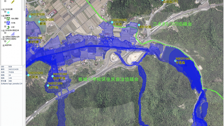
This web mapping application empowers anyone residing near these reservoirs with vital information. Imagine knowing in advance the potential impact of a reservoir failure due to events like earthquakes or heavy typhoon rains. Citizens can now easily ascertain if their homes or businesses are at risk, the time available for evacuation following a reservoir collapse, the projected inundation depth (displayed in vibrant color gradients), and the optimal evacuation routes to higher ground and emergency shelters.
Higashihiroshima City's territory is home to a staggering 1,821 priority-level agricultural reservoirs, surpassing all others in Hiroshima Prefecture. Additionally, the region boasts around 2,200 smaller irrigation ponds. Alarming statistics from 2018 reveal that 48 agricultural reservoirs in Hiroshima Prefecture suffered collapses, leading to unfortunate casualties. The hope is that this innovative application will foster awareness among citizens regarding the potential risks posed by nearby reservoirs, encouraging better preparedness.
Visualizing potential disasters
The application offers simulated flood presentations for each reservoir, assuming unfavourable conditions: a full reservoir and instantaneous collapse. For instance, if the Senzoku Reservoir in Saijo Town ward were to suddenly fail, floodwaters would reach National Highway 375, approximately 2 kilometres to the west, within just 15 minutes. Sections along the highway would be submerged under 2 to 3 metres of water.
Users can generate and download flood presentations for specific map areas as high-resolution PDF image files. These files can be used in reports or printed for handy reference during times of disaster.
The Higashihiroshima City reservoir hazard web mapping application is the brainchild of Tsukasa Consulting Co. in Japan. Developed using the DK for ASP.NET edition in collaboration with Microsoft Visual Studio and ASP.NET Web Forms, it seamlessly integrates the TatukGIS hosted OpenStreetMap tile server, complete with elevation contour lines and Japanese language labels. Furthermore, the application leverages DK support for the WMTS (Web Map Tile Service) protocol to incorporate an aerial image layer sourced from the Japan Geographic Survey Institute WMTS server. Locally stored vector map layers are in the SHP file format and/or TatukGIS SQL native structure format running on an SQLite database. The DK's ability to reproject layers on-the-fly ensures compatibility with the map presentation coordinate system, while also offering a convenient print to PDF functionality. The application operates smoothly on IIS Windows 11.
Higashihiroshima City's pioneering initiative brings an invaluable tool to its residents, equipping them with the knowledge and resources needed to face the ever-present threat of flooding head-on. Together, they are forging a safer, more resilient future.


Value staying current with geomatics?
Stay on the map with our expertly curated newsletters.
We provide educational insights, industry updates, and inspiring stories to help you learn, grow, and reach your full potential in your field. Don't miss out - subscribe today and ensure you're always informed, educated, and inspired.
Choose your newsletter(s)


