Exyn presents new modular 3D mapping solution
Exyn Technologies has unveiled Exyn Nexys, an innovative modular 3D mapping solution. Designed for professionals in the mining, construction, AEC and geospatial industries, Nexys aims to set a new standard in autonomous mapping technology, offering unparalleled flexibility, speed and accuracy in the most demanding surveying and inspection environments. Exyn Technologies is a pioneer in autonomous robotics.
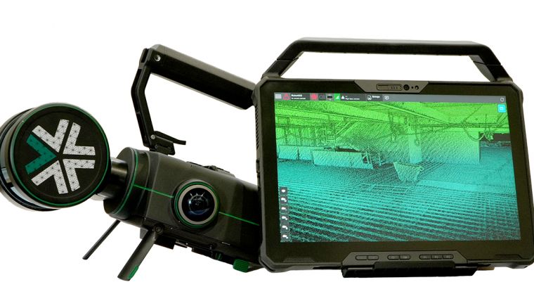
Nexys’ groundbreaking modular design allows for deployment in various configurations, whether handheld, backpack-mounted, vehicle-mounted, drone-integrated or via ground robots. This adaptability makes Nexys an essential tool for comprehensive mapping across diverse environments, from indoor and underground spaces to rugged outdoor terrains.
Equipped with the latest technology and Exyn's proprietary SLAM algorithms, Nexys delivers top-tier data capture speeds and real-time point cloud colourization. Attached to a robot, its Autonomy Level 4 (AL-4) capabilities facilitate intelligent autonomous navigation through dynamic, complex environments, ensuring thorough coverage even in GPS-denied settings, representing a significant advancement in autonomous mapping.
Real-time data visualization and precision accuracy
Thanks to the integrated hemispherical cameras, Nexys offers real-time visualization of detailed, colourized data directly onto a 3D point cloud. With the capability to capture up to 1.9 million scan points per second, it ensures survey-grade accuracy, guaranteeing precision up to 5mm at one standard deviation.
Constructed to IP67 standards within an ISO 9001-certified framework, Nexys is engineered to withstand the toughest conditions. Its ergonomic design, complemented by a comprehensive suite of accessories such as GNSS modules, protective cages and Drone Link for robot integration, enhances its versatility across various mapping scenarios.
Nexys is bundled with a durable Dell Latitude tablet, facilitating seamless mission planning for autonomous aerial exploration endeavours or monitoring real-time updates during mobile 3D mapping captures.
Meeting growing demand
More than just a product, Nexys represents an ecosystem designed by Exyn to boost mapping and surveying practices across multiple sectors. It embodies the company's direction towards commitment to enhancing safety, efficiency and accuracy in professional mapping projects. The new solution also meets a growing demand for this type of equipment, as illustrated by the most recent annual geospatial industry survey conducted by GIM International. The findings from that survey are analysed in the upcoming Business Guide edition – which will be published online in early March – and will also be featured in the newsletter of 7 March.

Value staying current with geomatics?
Stay on the map with our expertly curated newsletters.
We provide educational insights, industry updates, and inspiring stories to help you learn, grow, and reach your full potential in your field. Don't miss out - subscribe today and ensure you're always informed, educated, and inspired.
Choose your newsletter(s)


