South East Community College/Surv & Cad

Geo-matching.com has recently added CAD Software to its broad spectrum of product categories. Pythagoras and Orthograph Architect are the first suppliers in this category. In addition to general specifications, detailed...
Intergraph is the first computer-aided dispatch (CAD) provider supporting the Unified Incident Command and Decision Support (UICDS) project. UICDS is sponsored by the Science and Technology Directorate of the U.S....
Sivan Design Ltd was founded by its present CEO, Shlomo Sivan and David Sivan, and incorporated as a privately held company in 1996. Since its inception the company has been...
Troy University in Alabama, USA, has developed a 3D GIS model of the campus. As increasing national and international enrolment is part of the university’s mission, the 3D model will...
Bentley is offering a new software environment for managing spatial data, saying "Unlike a GIS, which requires data to adhere to a strict relational data model, Geospatial Management gives spatial...
Bentley is offering a new software environment for managing spatial data, saying "Unlike a GIS, which requires data to adhere to a strict relational data model, Geospatial Management gives spatial...
Toposcopy combines geo-referenced visualisation and close-range photogrammetry, using low-cost digital camera and CAD data. It has recently been successfully used to reconstruct a simulated traffic accident from video images. The...
DAT/EM Systems International (AK, USA) has communcated the compatibility of SUMMIT EVOLUTION with various CAD software packages. Currently, DAT/EM Systems SUMMIT EVOLUTION Digital Stereoplotter is fully compatible with: AutoCAD, Versions...
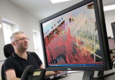
Engineering consultancy Hatch has transformed its handling of laser-scanned data on major infrastructure projects by using Pointfuse software to classify and manipulate billions of individual measurements. Originally used on a...
This site uses cookies. By continuing to use this website, you agree to our Cookies Policy. Agree