Lidar survey in cloudy conditions in Cameroon
A dynamic field of view feature was used to overcome the inability of Lidar laser beams to penetrate persistent cloud cover in this project in Cameroon. In Lidar surveys, minimizing...
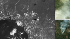
A dynamic field of view feature was used to overcome the inability of Lidar laser beams to penetrate persistent cloud cover in this project in Cameroon. In Lidar surveys, minimizing...
Smart digital realities that replicate real-life geoinformation provide valuable insights and support the analysis and interpretation of infinite data inputs from the real or digital world. They can be used...
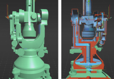
A recent project has celebrated 100 years of geodetic and photogrammetric innovation by 3D-digitizing an iconic WILD T2 theodolite from the 1927 series. An app has also been developed for...

On social media, the average post receives only a few seconds of attention. At trade shows, first impressions determine whether attendees visit a booth. The first moments also set the...
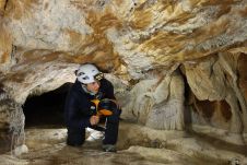
Geospatial mapping specialists and technology from GeoSLAM have been involved in a project to map the Lombrives cave in southern France. The Human Adaption Institute conducted a pioneering isolation experiment...

An inertial navigation system (INS) is a critical part of a surveyor’s armoury. The measurements provided by the INS, including heading, pitch/roll, timing and absolute position, ensure that surveyors can confidently measure their environment, safe in the knowledge that every area and angle is covered precisely. An inertial navigation system (INS) is a critical part of a surveyor’s armoury. The measurements provided by the INS, including heading, pitch/roll, timing and absolute position, ensure that surveyors can...
Septentrio has launched a new product line of high-performance GNSS/INS receivers called AsteRx-i3. The AsteRx-i3 product family brings to market an array of next-generation receivers from plug-and-play navigation solutions to...

Harxon has just launched its TS112 family of smart antennas, designed for demanding applications such as autosteering systems for agricultural machinery that require high positioning-accuracy solutions. The newly released TS112...

The European GNSS Agency (GSA), in collaboration with the Council of European Geodetic Surveyors (CLGE), has launched the Geomatics on the Move 2020 competition with the aim of fostering the use of...

Mark Heine is chairman of the board and CEO of Fugro, with the headquarters in the Netherlands. Fugro is the leading and largest specialised survey company in the world, serving the full lifecycle of assets, and calls itself a Geo-data specialist. For the avid mountaineer Heine, challenges are never too high to take on, not even heading up a multinational in transition, from a company largely dependent on the oil and gas industry to one that wants to co-create a sustainable and liveable world. We talked to Mark Heine about leadership style, strategies for finding new employees, and Seabed 2030. About this ambitious project, Heine says ‘Commercial companies need to work together with NGOs and academia to make this happen.’ Mark Heine is chairman of the board and CEO of Fugro, which is headquartered in the Netherlands. Fugro is among the leading and largest specialized survey companies in the world,...
This site uses cookies. By continuing to use this website, you agree to our Cookies Policy. Agree