Analysing 3D Laser Data with a Mouse Click
The Dutch high-tech company GeoSignum has presented a new method for extracting and analysing 3D laser data on geographical features and urban structures. The new web platform called GeoSignum Pointer...
The Dutch high-tech company GeoSignum has presented a new method for extracting and analysing 3D laser data on geographical features and urban structures. The new web platform called GeoSignum Pointer...

With deep sorrow, ASPRS has informed GIM International of the loss of a respected and long-time member, past president, friend and mentor, Carolyn Jean Merry, PhD, retired professor and chair...

Pointfuse, the automated point cloud processing software from Arithmetica, will be released as stand-alone software at Intergeo 2014. Offering a fast and precise yet flexible way of converting laser scanner...
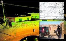
To be useful, the millions or even billions of 3D points generated by a variety of active and passive sensors need to be stored, organised, combined, georeferenced, measured and analysed,...

The UK needs to define the geospatial job category, says one of our European colleagues. He’s on the money there for sure and chartered surveyors need to be in the...
To be useful, the millions or even billions of 3D points generated by a variety of active and passive sensors need to be stored, organised, combined, georeferenced, measured and analysed,...
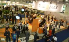
UAVs as platforms or systems were very much to the fore at this year’s INTERGEO. But so was software, reports editor Stephen Booth. In one of the six exhibition halls...

A UAS intended for mapping, inspection or reconnaissance consists of a mix of elements including aircraft, a ground control station (GCS), on-board navigation sensors, a radio link for manual control...
Collecting and processing point clouds has been trending topic in the geospatial sector over the past few years. This article focuses on point cloud processing software aimed at creating DEMs...
The year ahead offers better opportunities than we’ve had since the financial crash of 2008. But it does need members to engage in events and in their journal. Tell us...
This site uses cookies. By continuing to use this website, you agree to our Cookies Policy. Agree