Matija Zupan
Matija Zupan is a certified drone operator and QA manager at Slovenian geospatial software developer 3Dsurvey. He made his way into photogrammetry through geology, geotechnical engineering, and natural hazard modelling...

Matija Zupan is a certified drone operator and QA manager at Slovenian geospatial software developer 3Dsurvey. He made his way into photogrammetry through geology, geotechnical engineering, and natural hazard modelling...
Trimble has updated its core real-time monitoring software – Trimble 4D Control. Building on the recently released version 5.0, this update delivers support for Senceive’s wireless monitoring systems, streamlining the...
Whenever new objects have to be created, be it on or below the land and water, construction plays a role. The construction process often starts with surveying, either [marine surveying]...
Gaia Engineers Ltd, based in Auckland, New Zealand, has acquired Maptek I-Site Studio and Maptek Eureka for their civil engineering practice. Gaia saw the need for smart automated tools to...
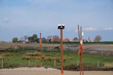
The Locator One solution for autonomous GNSS-based precision measuring has been sold and leased to numerous construction and infrastructure companies, both in the Netherlands and internationally. It was jointly developed...
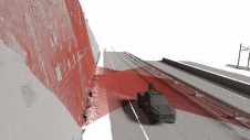
Exploring the complete potential of mobile laser scanning raises the question of whether the obtained results are sufficiently accurate for deformation monitoring. This article focuses on the geometric quality of...
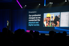
The Trimble Dimensions+ User Conference would be a good place to start for anyone aiming to reposition their business outlook or career in civil engineering, industrial technology, surveying and mapping...
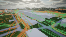
The digital twin concept has virtually exploded in recent years, but within the built environment the traditional term has long been ‘3D city model’. However, the digital twin is increasingly...
Trimble has introduced the latest version of its core geospatial automated monitoring software: Trimble 4D Control version 6.3. The software provides automated movement detection to enable informed decisions about infrastructure...
This site uses cookies. By continuing to use this website, you agree to our Cookies Policy. Agree