Land Tenure Services

In the ever-evolving landscape of climate change, geospatial science emerges as a key player in navigating the complexities of our transforming world. The European Association of Aerial Surveying Industries (EAASI)...
Success factors in secure land-tenure policy include robust collection of geospatial, anthropological and sociological data, acknowledging customary rights and land rights of women and the poor, and law enforcement capable...
On 29th June 2007 UN under-secretary-general and executive director of UN-Habitat Dr Anna Tibaijuka and ITC Rector Prof. Martien Molenaar signed a co-operation agreement to cluster their knowledge on urban...

The fourth edition of Geo Connect Asia (GCA), celebrated as the region's premier trade event and conference for the geospatial, positioning and remote sensing industries, truly delivered during its two-day...
The work of the World Bank focuses on achievement of the Millennium Development Goals that call for the elimination of poverty and sustained development. This month’s interviewee is responsible in...
The land surveying and registration system in Namibia covers only part of the country. There is frustration at the slow pace of planning, survey and registration of land rights and...

Despite some uncertainty, there is renewed interest in drones, and remote sensing technologies are being embraced by smaller survey companies. Read these and other findings from our annual industry survey!...

3D TARGET was founded as a trading company and official distributor of non-destructive measuring instruments. In 2016, we created an internal R&D division dedicated to system integration and designed a...
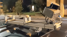
Klau Geomatics has introduced the Brumby RTK Lidar system, an innovative mobile mapping solution equipped with powerful Edge Compute capabilities, enabling the generation of highly precise georeferenced point clouds in...
This site uses cookies. By continuing to use this website, you agree to our Cookies Policy. Agree