Found 2512 results
Sort by

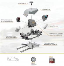
Trimble launches MX90 mobile mapping solution

Trimble has recently unveiled the Trimble MX90 mobile mapping system. Integrating advanced Trimble GNSS and inertial technology with Trimble field and office software, the MX90 offers a comprehensive field-to-finish mobile...

Read more

Mobile Laser Scanning Point Clouds

The demand for 3D maps of cities and road networks is steadily increasing and mobile mapping systems are often the preferred acquisition method for capturing such scenes. Manual processing of...

Read more

Mobile Laser Scanning Point Clouds

The demand for 3D maps of cities and road networks is steadily increasing and mobile mapping systems are often the preferred geodata acquisition method for capturing such scenes. Manual processing...

Read more

Laser Scanning on the Go

As the world's population keeps growing and changes in buildings and infrastructures become more rapid, there is an increasing need to document this growth and these changes. A revolutionary approach to...

Read more

Mobile Laser Scanning in Venice

High measurement rates and centimetre precision point-clouds are state-of-the-art in mobile laser scanning. The introduction of photogram­metric features as next logical step considerably expanded the horizon of potential applications. Digital...

Read more

Airborne and Terrestrial Laser Scanning

Last month we reported back from the Intergeo trade show that it was all about three abbreviations: Airborne Laser Scanning (ALS), Terrestrial Laser Scanning (TLS) and Mobile Laser Scanning (MLS)....

Read more