Qinertia photogrammetry picture match

Under the leadership of the Japan Association of Surveyors, the new Fodis Measure3D system was benchmarked against total stations and single frame array cameras for detecting RFID tag positions. One...
Taking images is the fastest and most reliable way to capture reality. Thirty years ago photogrammetrists dreamed of loading aerial images into a computer and within minutes retrieving - without...
Surveyors working on busy roads are constantly subjected to close misses from passing traffic; it can be worse. Helicopter photogrammetry is a survey technique designed to prevent fatalities. A complete,...

Sanja Šamanović is an assistant professor in the Department of Geodesy and Geomatics at the University North in Varaždin. She previously worked in the Faculty of Geodesy at the University...

Maxar Intelligence has been awarded a contract to supply the National Geospatial-Intelligence Agency (NGA) with a Precision3D Data Suite bundle. This comprehensive package covers an extensive area of 160,000 square...
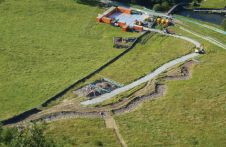
Structure-from-Motion photogrammetry and GIS are being used to chart the success of a river restoration project in Northern England. Many of the world’s rivers are degraded as a result of...

Germany-based technology company nFrames develops cutting-edge 3D surface reconstruction software designed for professional mapping production. Optimised for precision, speed and simplicity, the company’s core software product, SURE, is built to...

The race between data production and processing capacity has been going on for many decades, with data production usually on the winning team. This is also true for airborne and...
This site uses cookies. By continuing to use this website, you agree to our Cookies Policy. Agree