Satellite Imagery to Shell Desktops
ER Mapper (Australia) has rolled out a new software solution for Shell exploration and production that makes Shell's twelve terabyte archive of satellite imagery available to users throughout the world....
ER Mapper (Australia) has rolled out a new software solution for Shell exploration and production that makes Shell's twelve terabyte archive of satellite imagery available to users throughout the world....
DigitalGlobe (CO, USA) and DMTI Spatial Inc. (Canada) has announce the immediate availability of Satellite StreetView. Satellite StreetView is an imagery-mapping solution combining high-quality digital mapping data with the highest...
From locating and disarming landmines to combating illegal mining, monitoring armed conflict, mapping internally displaced populations and subsequent camps as well as tracking oil pollution affecting local citizen’s health and...
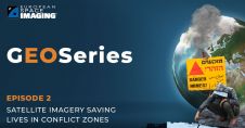
Satellite Imagery Saving Lives in Conflict Zones
PlanetScope is now accessible on Google Cloud Marketplace. This availability of Planet's flagship satellite imaging product contributes to the company's mission to democratize access to near-daily satellite imagery, enabling organizations...
Trimble has unveiled the integration of the Trimble Applanix POSPac Cloud post-processed kinematic (PPK) GNSS positioning service, featuring CenterPoint RTX, with the UAV-based mapping and data collection capabilities of DroneDeploy’s reality...
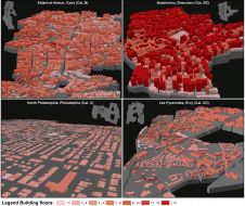
Hannes Taubenböck and his team at the German Aerospace Center (DLR) are using very high-resolution (VHR) satellite imagery, supplied by European Space Imaging, combined with auxiliary surveys to develop a...
Hannes Taubenböck and his team at the German Aerospace Center (DLR) are using very high-resolution (VHR) satellite imagery, supplied by European Space Imaging, combined with auxiliary surveys to develop a...

Airbus has announced a data-sharing agreement with satellite imagery purveyors Planet, along with a project to deliver a geoinformation platform and pipeline for the Thai government. The depth and breadth...

DigitalGlobe has released satellite imagery and data of the wildfires in California through their Open Data Program. The publically released imagery is for Ventura, California, and the surrounding communities and...
This site uses cookies. By continuing to use this website, you agree to our Cookies Policy. Agree