Roland Pail
Roland Pail is a professor of Astronomical and Physical Geodesy at the Technical University of Munich. His research activities focus on global and regional modelling of the Earth’s gravity field,...
Roland Pail is a professor of Astronomical and Physical Geodesy at the Technical University of Munich. His research activities focus on global and regional modelling of the Earth’s gravity field,...

Global reference systems such as the International Terrestrial Reference Frame provide the foundation for determining positions on Earth and in space, as well as for reliably quantifying our planet’s changes...
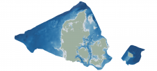
Through the collaborative implementation of satellite-derived bathymetry (SDB), the Danish Geodata Agency and EOMAP are synergizing efforts to contribute to the European Marine Observation and Data Network (EMODnet) Bathymetry partnership....
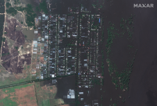
European Space Imaging (EUSI) partner, Maxar collected new high-resolution satellite imagery on 7 June amidst the aftermath of the collapse of the Nova Kakhovka Dam and the widespread flooding along...

Planet was founded with the mission to image the Earth every day and make change visible, accessible, and actionable. Over the past decade with our customers, Planet has revolutionized the...
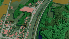
Innovative methodologies based on artificial intelligence (AI) are lowering the barriers and democratizing the use of 3D digital twins in the geospatial industry. Digital twins are revolutionizing the geospatial industry,...
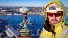
The revolutionary use of active GNSS control points and cutting-edge geomatics equipment is setting new standards for accuracy in the construction of high-rise architecture, as demonstrated by this skyscraper project...

SI Imaging Services (SIIS) has expanded its array through a new partnership agreement with satellite imaging platform company SkyFi which gives SkyFi access to SIIS’s VHR Korean Multi-Purpose Satellite (KOMPSAT)...

Both vertical and oblique aerial images have their own advantages, making them valuable in different reality mapping applications. So how can you choose between the two? This comparison will help...
It can still be difficult to achieve centimetre-level accuracy in mobile mapping, especially in GNSS-denied or challenging areas such as in deep urban canyons, under foliage or through tunnels. However,...
This site uses cookies. By continuing to use this website, you agree to our Cookies Policy. Agree