The importance of geodetic reference frames
A uniform basis to tackle current and future challenges
Global reference systems such as the International Terrestrial Reference Frame provide the foundation for determining positions on Earth and in space, as well as for reliably quantifying our planet’s changes due to geodynamic processes and ongoing climate change. A global reference frame ensures a uniform basis for geospatial data. Moreover, it is needed for all positioning and satellite navigation applications, and thus plays an elementary role in modern society.
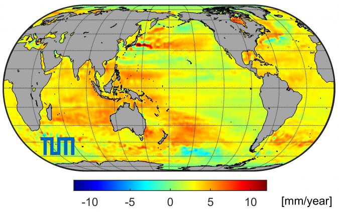
Numerous media reports inform us that the global sea level is rising. According to the Sixth Assessment Report of the Intergovernmental Panel on Climate Change (IPCC Report 2021), the current mean sea level rise is 3.7mm per year, whereas over the last century it was ‘only’ approximately 1.5mm per year. This significant increase in mean sea level rise is not surprising, since global warming is accelerating the melting of ice masses and the thermal expansion of ocean water. However, it is also important to look beyond these average values for all the oceans because, as shown in Figure 1, there are large regional differences. In some regions off the American west coast the sea level is actually falling, but there are much larger regions where sea level is rising by up to one centimetre per year. Such a rapid sea level rise affects not only island regions (most of which are only just above sea level), but also many densely populated coastal regions. The associated risks of flooding and loss of habitats represent an enormous threat and can result in major migration movements and social conflicts. Therefore, precise knowledge of this climate change phenomenon is essential for decision-makers and society. But how can sea level rise be measured so precisely?
The need for a precise global reference
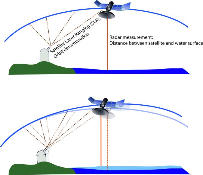
Precise orbits of altimetry satellites are one prerequisite for a reliable determination of sea level variations. As a fundamental basis, this requires an accurate global reference that remains stable in the long term. As an example, Figure 2 shows how an inaccurate reference frame can lead to an incorrect determination of sea level. In this illustration, the orbit of the altimetry satellite is determined with laser ranging, and the distance between the satellite and the ocean surface is measured with a radar altimeter. If the station moves without being correctly described by the parameters of the reference frame, the same radar measurement will result in a different satellite orbit. This creates an apparent rise in sea level, although in reality it is the observation station that has changed.
In order to assess the impact of sea level rise in a particular region, it is important to know the sea level change relative to the land. It is therefore also necessary to determine whether the land itself is rising or subsiding. This again requires an accurate and stable reference frame as a metrological basis. Fennoscandia, for example, is rising as a consequence of melting of ice masses of the last ice age (postglacial uplift), but other coastal regions are subsiding, for instance due to geodynamic or human-made effects such as extensive ground water withdrawal. Jakarta, Indonesia’s capital, is an alarming example of the latter effect. It is regarded as one of the fastest-sinking cities in the world, with half of the city already below sea level and the forecast not looking promising.
Due to the potential societal impact of sea level rise, it is a key driving factor in the high accuracy requirements for the global geodetic reference frame. The target set by the International Association of Geodesy (IAG) is a positional accuracy of one millimetre, and the long-term stability is to be one millimetre per decade. This is a challenge for geodetic work.
Wide range of applications
Apart from sea level monitoring, there are many other tasks in modern society that require a precise global reference. These applications include not only geodetic tasks (e.g. surveying, engineering, mapping, photogrammetry, geoinformation, land/resource management and cadastre), but also other geosciences (e.g. geophysics, oceanography, hydrology, meteorology and climatology) and astronomy. A uniform reference is also required for determining the effects of climate change and for operating early-warning systems to protect against natural hazards. Moreover, the huge and ever-growing GNSS market – in which more than six billion devices are already in use today – draws on countless location-based applications (navigation, traffic and fleet management, transport logistics, control of industrial and agriculture machinery, autonomous driving, …) that now deeply pervade daily life.
How is the global reference frame defined?
The metrological basis is a uniform global coordinate system of the Earth. Such a coordinate system –called a ‘geodetic reference system’ in geodesy – is a mathematical construct in which every point on the surface, inside and outside the Earth, can be described with unique coordinates. For a meaningful interpretation of how the planet is changing, it is essential that the coordinate system is fixed and does not change over time.
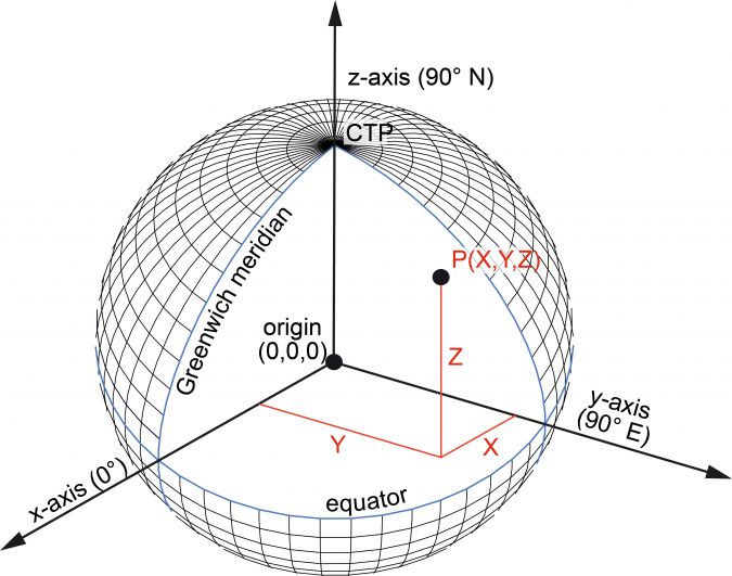
The fundamental global geodetic reference system in use today is the International Terrestrial Reference System (ITRS). It was established as the primary global geodetic reference system by a resolution of the International Union of Geodesy and Geophysics (IUGG) in 2007. The ITRS is a Cartesian coordinate system, in which the position of a point is described with three metric values (X, Y, Z) with respect to three coordinate axes perpendicular to each other (Figure 3). The origin of the ITRS is the centre of mass of the Earth, including its atmosphere and oceans. The scale (unit of length) is the metre. According to the conventions of the International Earth Rotation and Reference Systems Service (IERS), the axis directions refer to a historical definition of the Greenwich meridian (x-axis), a historical direction of the Earth’s mean axis of rotation (z-axis), and the conventional equator plane perpendicular to this axis.
How is the reference system realized?
For all practical applications, the theoretically defined reference system must be realized. This is done by determining the 3D coordinates of firmly anchored points on the Earth’s surface. These points are worldwide distributed observation stations, whose coordinates are computed consistently with the system definition with space geodetic observation techniques. Through them, the reference system is materialized and made accessible. The realization of the ITRS is called the International Terrestrial Reference Frame (ITRF).
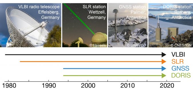
Four space geodetic observation techniques are currently used for the ITRF computation: Very Long Baseline Interferometry (VLBI), Satellite Laser Ranging (SLR), Global Navigation Satellite Systems (GNSS), and Doppler Orbitography and Radiopositioning Integrated by Satellite (DORIS). These four observation techniques now provide observations over 25 to 40 years (Figure 4).
The (re-)processing of the VLBI, SLR, GNSS and DORIS observations over this long time span is a tremendous effort, which is done by the corresponding Scientific Services of the IAG. The three ITRS Combination Centers of the IERS, namely the Institute national de l’information géographique et forestière (IGN) in Paris, the Deutsches Geodätisches Forschungsinstitut of the Technical University of Munich (DGFI-TUM), and the Jet Propulsion Laboratory (JPL) of NASA in Pasadena, are responsible for the combination of the data provided by the four technique-specific IAG Services. The availability of three ITRS solutions ensures an evaluation of the quality of the final product, which is then released by the ITRS Center at IGN.
The key role of geodetic observatories
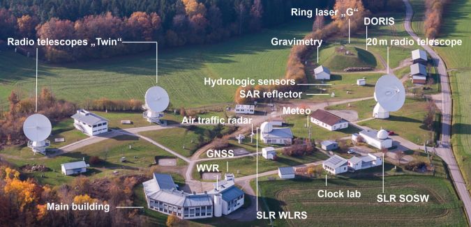
One of the greatest challenges in the ITRF calculation is to optimally combine the four space geodetic observation techniques into a consistent reference frame. Essential for this task are globally distributed geodetic observatories, on which several observation techniques are operated in parallel. Figure 5 shows the Geodetic Observatory Wettzell in the Bavarian Forest, Germany. With the four space techniques VLBI, SLR, GNSS and DORIS running in parallel, this station is one of the most important ‘core sites’ of IAG’s Global Geodetic Observing System (GGOS). Apart from Wettzell, there are only a handful of other fundamental stations on which all four space techniques are installed.
Current realization of the International Terrestrial Reference System
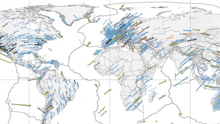
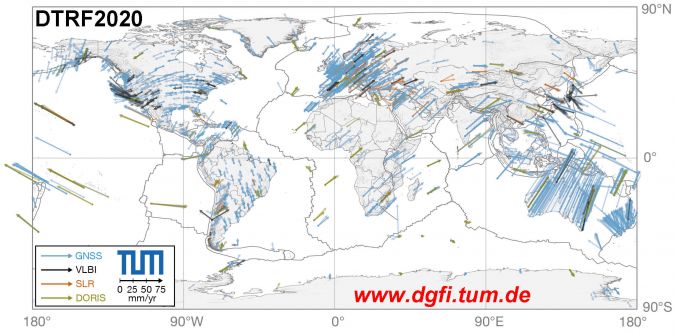
In 2022, the latest ITRS realization ITRF2020 was published by the responsible ITRS Combination Center in Paris as the successor of the previous realization, ITRF2014. It contains 25 to 40 years of VLBI, SLR, GNSS and DORIS data until the end of 2020 (Figure 4) and comprises 3D station coordinates and velocities of approximately 1,900 globally distributed observing stations. The horizontal velocities of the stations as provided by the latest ITRS realization of DGFI-TUM, the DTRF2020, are shown in Figure 6. The clearly visible station motions reflect plate tectonics (with the boundaries of the lithospheric plates indicated by grey lines).
Conclusion
The realization of the global geodetic reference system ITRS provides the global reference for all geospatial data and for many tasks in modern society. With a position accuracy of approximately 5mm and a stability of 0.5mm per year, current ITRF solutions surpass all previous versions. However, the ambitious targets of the IAG have not yet been reached. The task is to further improve the accuracy of the space geodetic observation techniques in order to implement new models and refined analysis strategies. Additionally, a better global distribution of geodetic observatories is required. The adoption of the United Nations resolution ‘Global Geodetic Reference Frame for Sustainable Development’ in 2015, underlining the great importance of the geodetic reference frame for societal demands, was an outstanding milestone in international geodesy.
Further reading
Angermann D., Pail R., Seitz F., Hugentobler U. (2022). Mission Earth – Geodynamics and Climate Change Observed Through Satellite Geodesy, Springer, https://doi.org/10.1007/978-3-662-64106-4

Value staying current with geomatics?
Stay on the map with our expertly curated newsletters.
We provide educational insights, industry updates, and inspiring stories to help you learn, grow, and reach your full potential in your field. Don't miss out - subscribe today and ensure you're always informed, educated, and inspired.
Choose your newsletter(s)


