Today’s GIS technology puts multipurpose cadastre within reach
Bridging the gap between vision and reality
There are indications that today’s technological advances are putting a fully operational multipurpose cadastre within reach, following decades of a global vision and small-scale progress towards a comprehensive map-centric land rights system. This is being accelerated by the increased concern for disaster mitigation, climate mitigation and sustainable development, and the need for integration, sharing and collaboration between agencies.
Ever since the US National Research Council (NRC) published the groundbreaking ‘Need for a Multipurpose Cadastre’ report in 1980, there has been a global vision for implementing a system that represents all land rights, restrictions and responsibilities in a geographic context or map-centric system. Since then, much work has been done in the direction of multipurpose cadastre (MPC), mostly on a small, localized scale. Modernization, digitalization and automation have occurred in many government agencies with land information systems – registry, valuation, planning, natural resources, administrative records and others – but a fully operational MPC has yet to be realized.
While the content of land records has long been considered a function of local government (NRC, 1980), users now require precise spatial information in real time for the ability to develop and implement cross-jurisdictional and inter-agency solutions that are designed to meet priorities such as disaster response, climate mitigation and sustainable development goals (Williamson, 2008). In turn, these solutions are prompting greater consideration of how to integrate, share and collaborate with other agencies that are also managing land for a single, comprehensive view of authoritative land information. This pattern proliferates globally.
Vision versus reality
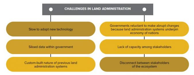
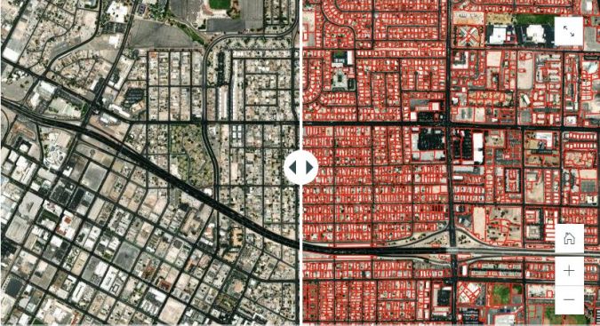
While the vision of an MPC is relatively straightforward in concept, the time that has elapsed since the 1980 report highlights some very real challenges in making that concept a reality (Figure 1). This lack of operational realization is due to a number of factors. In many countries, including the USA, land information is stored and maintained at local and state/provincial jurisdictions. Adding further complexity are the land information silos that exist in these jurisdictions. For instance, information necessary for valuation and taxation purposes is often compiled and maintained by valuation officials. Data involving real property transactions might be maintained and managed by a different group, often in a registry or recording office. If a mapping component exists, it may be with one group or the other but not necessarily linked together and, in some instances, mapping is maintained by an entirely different department.
Records have also traditionally been stored in a wide array of systems: some paper-based and others computerized. Many of the computerized systems are proprietary in nature or are limited in their ability to be interoperable with other systems due to inherence to open standards. The government tendency is for slow adoption of technology and for abrupt change in general because land administration systems underpin the economy of nations (GKI, 2022). The result is siloed data and static or transactional data sharing between all organizations, both private and public, with a vested interest in land information.
The 1980 US National Research Council report cited capacity as a concern for the viability of developing an MPC. That issue persists today and, along with little to no resource commitment at the federal level, it has contributed to slow progress towards an MPC.
Advancements in GIS technology
Modern geographic information systems (GIS) technology has evolved and is now capable of sharing and aggregating land information from disparate government departments to deliver single, authoritative access to the nature and extent of property rights, restrictions and responsibilities. This ability to share and aggregate data more readily provides a solution that helps address some of the challenges in land administration (Figure 1) which continue to hold back progress towards an MPC. Efficiency and accuracy are gained by limiting manual transmission of data, duplication of effort and using current data straight from the source. These advantages cannot be understated in a world fraught with accelerating challenges and the need for new discoveries.
Substantial advances in recent years mean that artificial intelligence (AI) is continuing to mature and grow in sophistication. With the ability to match, or in some cases even surpass, human accuracy at tasks such as image recognition, reading comprehension and translating text (Land, 2022), the capacity challenge in realizing an MPC may soon find some relief.
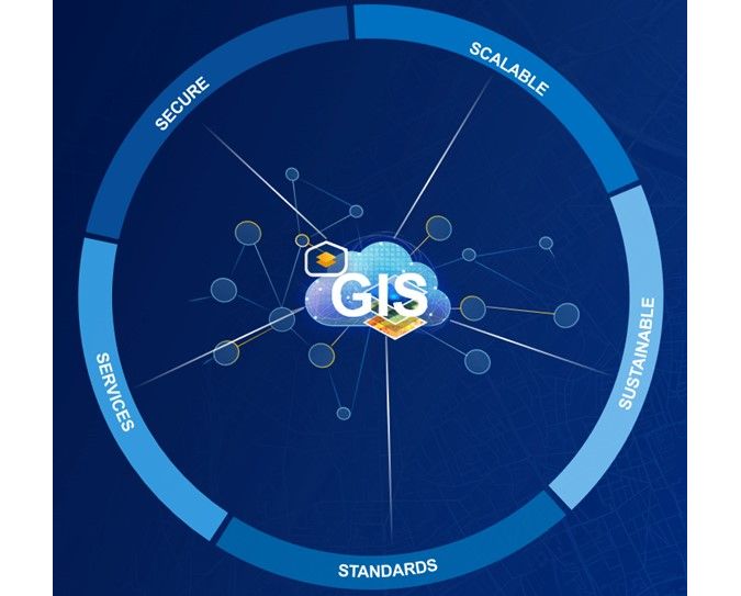
5 characteristics of GIS
The following five key characteristics of modern GIS technology promote sharing and aggregating of land information (Figure 2):
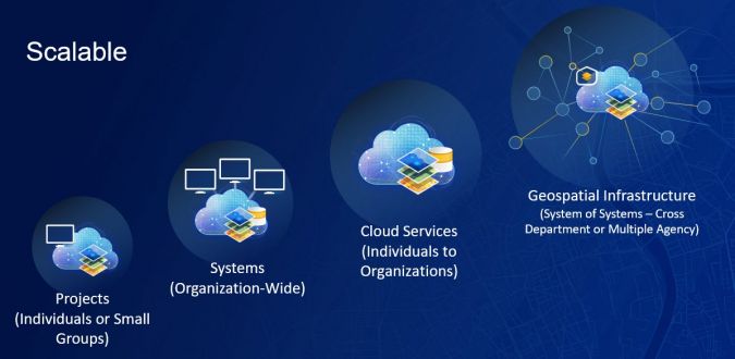
- Scalability: The scalability of modern GIS provides the opportunity for organizations of any size, and at any stage in their land administration odyssey, to fully realize the benefits of modern GIS. Whether working at an individual project level or as a multi-faceted organization comprised of many teams, there is a suitable configuration (Figure 3).
- Security: Modern GIS technology, and specifically commercial, off-the-shelf software (COTS), is designed and managed in alignment with regulations, standards and best practices. Comprehensive security is provided throughout the ecosystem including products and services, solutions, cloud infrastructure, and specific privacy and security initiatives (e.g. GDPR and FedRAMP).
-
Standards and interoperability: With a decades-long commitment to open standards and interoperability, modern GIS technology continues to contribute to and support international standards development, and has a history of open-sourcing its format specifications. With support for reading and writing standard and common data file types using industry and international standard data formats, and via the web through Open Geospatial Consortium (OGC) services, GIS technology provides the interoperability needed to meet the evolving needs of the land administration community.
-
Services through the web: Utilizing web services allows all government agencies to remain focused on their areas of responsibility while sharing up-to-date, authoritative data to a single point of access for use by agencies and others with overlapping interests. Efficiency and accuracy are gained by limiting manual transmission of data and duplication of effort, and by using current data straight from the source. These are advantages that cannot be understated in a world fraught with accelerating challenges and the need for new discoveries.
-
Sustainability: Long-term sustainability is the sum of the preceding four characteristics of a modern GIS. System sustainability is critical in the pursuit to achieve an MPC. As noted previously, one of the challenges in realizing an MPC is the custom-built nature of legacy land administration systems. Custom-built systems are often vulnerable to security threats, require a high-level of specialized maintenance, and are susceptible to high levels of technical debt.
Artificial intelligence
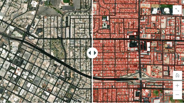
Generally speaking, AI is the ability of computers to perform tasks that typically require some level of human intelligence (Land, 2022). The intersection of AI and GIS, referred to as geoAI, is creating enormous opportunities in the land administration space. Two areas showing promise are the detection of cadastral boundaries from remotely sensed imagery (Figure 4) and the mapping of boundary descriptions from scanned documents using techniques like natural language processing (NLP) and machine learning (ML).
Each approach applies to different stages of land administration maturity. Boundary detection from imagery is being explored as an alternative to ‘boots on the ground’ surveying to expedite the first registration of land, thus securing property rights and mobilizing land capital. Mapping of boundaries from existing documentation is intended to propel those organizations that have land registered in paper form, but not accessible in a mapped, digital format. First registration mapping or converting paper records into a digital format is the first step in the process towards realizing an MPC.
Conclusion
Although a widespread operationalized MPC has yet to be realized, all indications are that technological advances and increased concern for disaster mitigation, climate mitigation and sustainable development are accelerating the process. In the USA, for example, a number of statewide parcel aggregation projects have been successfully completed, and the federal government recently passed the FLAIR Act which calls for the creation of a current, accurate inventory (cadastre) of federal land. Both signify a commitment to larger land administration projects needed to eventually achieve an MPC.
By leveraging today’s GIS technology and standards such as the Land Administration Domain Model (LADM), OGC standards and globally available base maps, imagery and data, achieving a multipurpose cadastre can be a reality.
Further reading
Geospatial World and UN Statistics Division. ‘Geospatial Knowledge Infrastructure’, 2022. https://www.geospatialworld.net/consulting/gki-phase-2/report.html
Land, Nick. ‘Automating National Mapping & Cadastre with GeoAI’, 2022. https://www.fig.net/resources/proceedings/fig_proceedings/fig2022/papers/ts03e/TS03E_land_11424.pdf
National Research Council. ‘Need for a Multipurpose Cadastre’, 1980. https://www.ngs.noaa.gov/PUBS_LIB/NeedforMultiCadast.PDF
Ting, Lisa and Williamson, Ian. ‘Land Administration and Cadastral Trends: The Impact of the Changing Humankind-Land Relationship and Major Global Drivers’, 2000. https://www.researchgate.net/publication/2822904_Land_Administration_and_Cadastral_Trends_The_Impact_of_the_Changing_Humankind-Land_Relationship_and_Major_Global_Drivers
Williamson, Ian. ‘Global Challenges for Land Administration and Sustainable Development’, 2008. https://www.lincolninst.edu/sites/default/files/pubfiles/1239_Williamson%20Final.pdf

Value staying current with geomatics?
Stay on the map with our expertly curated newsletters.
We provide educational insights, industry updates, and inspiring stories to help you learn, grow, and reach your full potential in your field. Don't miss out - subscribe today and ensure you're always informed, educated, and inspired.
Choose your newsletter(s)


