Assessing environmental changes with GNSS reflectometry
An innovative geodetic tool called GNSS-IR is a more effective technique than tide gauge for monitoring sea surface height as the basis for modelling sea level variations, according to the...

An innovative geodetic tool called GNSS-IR is a more effective technique than tide gauge for monitoring sea surface height as the basis for modelling sea level variations, according to the...

Airbus has launched the Pléiades Neo Next programme to expand its very high-resolution Earth observation constellation. This new programme will introduce new satellite assets and capabilities, including enhanced native resolution....

In the ever-evolving landscape of climate change, geospatial science emerges as a key player in navigating the complexities of our transforming world. The European Association of Aerial Surveying Industries (EAASI)...

The fourth edition of Geo Connect Asia (GCA), celebrated as the region's premier trade event and conference for the geospatial, positioning and remote sensing industries, truly delivered during its two-day...
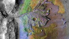
Using ground-penetrating radar, NASA’s Perseverance rover has uncovered compelling evidence of ancient lake sediment on Mars. This confirms the longstanding hypothesis that the Red Planet was once a warm, wet...
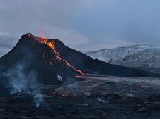
The Icelandic authorities have commissioned Acecore to map the extent and aftermath of the Eldvörp-Svartsengi volcanic system eruption using its high-end drone solutions. Grindavík, a fishing village on the Reykjanes...

Intermap has won a US$20 million contract to map the Indonesian island of Sulawesi this year. The contract is the first phase of the Indonesian national topographic basemap programme to...

Global reference systems such as the International Terrestrial Reference Frame provide the foundation for determining positions on Earth and in space, as well as for reliably quantifying our planet’s changes...
Satellite imagery is becoming increasingly important for creating Digital Surface Models (DSM) covering countries, continents or even the global entire landmass. If a scene is recorded from two or more...
This site uses cookies. By continuing to use this website, you agree to our Cookies Policy. Agree