How digital twins add value in urban planning
As more and more cities are deciding to work with a digital twin, we have selected a number of articles that outline how digital twins are created and how they...

As more and more cities are deciding to work with a digital twin, we have selected a number of articles that outline how digital twins are created and how they...
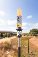
Topcon Positioning Systems has presented the latest addition to its HiPer family of global navigation satellite system (GNSS) receivers. The HiPer CR is a compact and lightweight GNSS receiver designed...

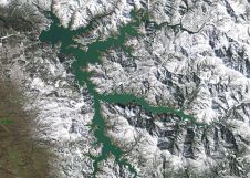
A topobathymetric Lidar survey was conducted to support flood preparedness in Canada. Which techniques achieved exceptional precision, and what were the logistical challenges? Find out more in this article. As...

Diamond Aircraft and Vexcel Imaging have announced the next collaboration for a further expansion of Diamond’s special mission aircraft high-end sensor portfolio. The partnership will integrate the UltraCam Dragon 4.1...

Visitor registration is now open for GEO Business, the UK's largest geospatial event. The free-to-attend expo, tailored for geospatial professionals seeking to harness the potential of location intelligence, will return...

Spatineo and its partner GIS-kvalitet i Norden recently supported Lantmäteriet, the National Land Survey of Sweden, in answering an essential and important question: 'What is the economic benefit of national ...
PlanetScope is now accessible on Google Cloud Marketplace. This availability of Planet's flagship satellite imaging product contributes to the company's mission to democratize access to near-daily satellite imagery, enabling organizations...
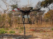
British mine-clearance charity The HALO Trust partnered with Routescene to undertake a UAV Lidar project in Cuito Cuanavale, in the Angolan province of Cuando Cubango. This case study demonstrates the...

Urban planning is a profession which is experiencing big changes as a result of advances in geospatial and other technology. In this article, Niall Conway explains why planning is too...

Esri has announced the release of CityEngine 2017. This version of the 3D modelling software offers features that let planners and architects compare different scenarios and visualize them with dashboards...
This site uses cookies. By continuing to use this website, you agree to our Cookies Policy. Agree