Remote sensing surveys in Antarctica based on unmanned aerial vehicles (UAVs or ‘drones’) have become a very important approach for a wide range of studies. Mapping free-from-ice-and-snow terrain and monitoring penguin colonies are among the demanding initiatives in fast-changing Antarctica. The ability to develop precise remote observations on distant, large-scale and hazardous terrains makes the usage of UAVs equipped with cameras, Lidar and other sensors indispensable. This article highlights a number of UAV-based campaigns by the Bulgarian Antarctic Institute to gain more accurate and efficient insights into the situation on Livingston, South Shetland Islands, Antarctica.
The Bulgarian Antarctic Institute hosted three UAV-based campaigns to observe terrains on Livingston Island: to study the dynamics of the Perunika glacier (from 2017 to 2018), and to capture the shoreline from the Perunika glacier up to Johnson Dock, Caleta Argentina, the Rocosso rock glacier, Moores Peak, Mirador Hill, Nunatak de Castillo, Point and some others (from 2018 to 2019). Newly-released-from-ice-and-snow terrain due to global warming offers opportunities for extensive studies for both geologists and biologists.
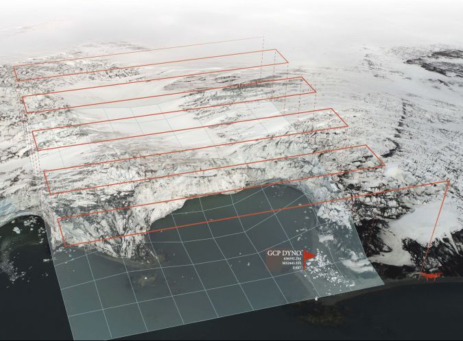
High-efficiency photogrammetric observations of glacier
The main UAV flight targets in the 2017-2018 campaign were terrains that were clear of snow and ice, and glacier formations (with a special focus on the Perunika glacier). A 3D model for Perunika glacier were reconstructed in order ease the ground based measurements of the surface velocity.
The 2018-2019 campaign was focused on the use of a UAV on Livingston Island to enable the creation of a 3D model of a distant rock formation situated on the shoreline of the Pimpirev glacier. The take-off point was at the Bulgarian base. This approach was useful, safe, fast and descriptive. This method of aerial survey enabled analysis of the rock structure and detailed estimation of the geomorphology of the island, despite the area being inaccessible both on foot and by boat. Comparing digital elevation models (DEMs) from different epochs allows analysis of the erosive events at high resolution.
Supporting rescue missions
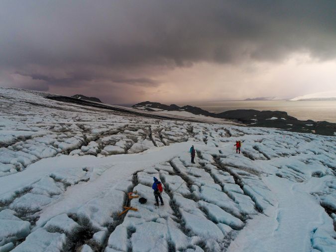
Safety and rescue have always been given very high priority at St. Climent Ohridski, the Bulgarian Antarctic base. An aerial survey was conducted of crevasses along the route through the Perunika glacier in 2018. The resulting UAV imagery and 3D models help researchers to trace the safest route through the crevasses along the glaciers and even through an icefall.
In terms of logistics support, the UAV-based method enabled the successful delivery of climbing equipment into a crevasse at Johnson Dock. This formed part of a simulation of a rescue mission in a hazardous area. Two UAVs were deployed: one to deliver the safety equipment (an ascender, a headlamp and a 120cm sling), and one to record a video of the mission. The distance between the take-off point and the delivery location was approx. 700m, the load weighed 385g and the hovering time in the crevasse was 6 minutes.
Testing and improvements
The technical equipment used is known to play a key role in the success of the flights. Therefore, in 2019, Topodrone PPK systems and cameras were tested for their ability to advance airborne photogrammetric data collection. Three improvements were applied: 1) Use of post-processing kinematic (PPK) technique to increase the geodetic accuracy and to minimize the number of Ground Control Points, 2) Flying in a terrain-follow mode in order to obtain a constant scale factor for the flight polygon, and 3) Performing terrain-follow-mode flights at low altitude for an area outside of Shuttle Radar Topography Mission (SRTM) service. This approach requires two sequential flights – the first flight was used to gather data for the DEM and the second flight was navigated based on the obtain information in terrain-follow mode in order to assure constant scale factor reprojection for the entire area. This improvement led to an orthomosaic with a resolution of 1.5px/cm. The precise geodetic accuracy was achieved by using L1/L2 GNSS receivers both on the ground base unit and the flying rover. The multi-battery flight technique allowed the and also resulted in shorter processing time. These improvements significantly boosted the flight-performance efficiency, because the processed flight area in 2019 was six times bigger than in 2018, based on the same amount of time spent in the field. The processing time was also reduced, which made it possible to perform the main data analysis during the campaign.
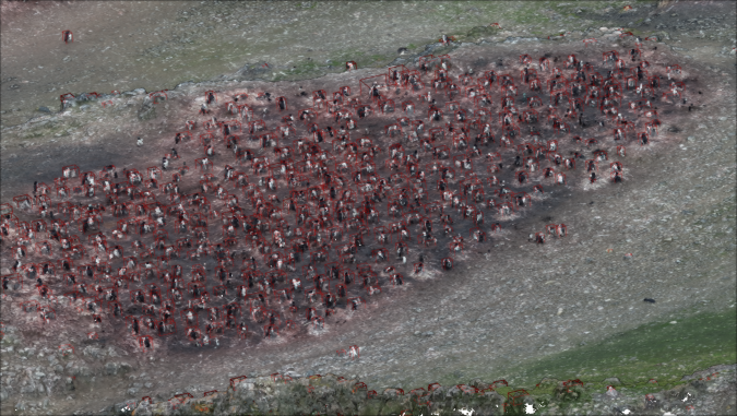
Remote monitoring of penguins during the nesting period
The Antarctic penguins are considered by scientists to be among the best indicators of the level of disturbance due to climate change. During the breeding period, the Antarctic penguins live in colonies situated close to the sea in areas that are clear of ice and snow. After a penguin has laid an egg (or usually two eggs), it remains still and upright in its nest for five to six weeks. This makes it easy to count the penguins in this period.
In order to monitor the penguins in detail in the field, the key parameters are: , amount of guano, and survival ratio of the chicks. Guano is the only parameter that can be monitored using satellite images. However, manual observations in which scientists physically visit colonies and walk among the penguins are known to create considerable stress for the penguins. Therefore, the Bulgarian Antarctic Institute ran two campaigns, comprising a total of eight UAV flights, at Hannah Point in 2019 and 2022. The flights were planned and executed in line with the requirements of the 2017 Scientific Committee on Antarctic Research (SCAR) report.
The team used a Topodrone DJI Phantom 4 PPK for a precise photogrammetric survey in terrain-follow mode. The use of a small UAV for remote sensing made the collection of the data less stressful for the penguins. It also delivered much more accurate data than is possible from satellite observation, plus it enabled data to be gathered even in the presence of low clouds.
Since the Antarctic penguins are only approximately 45-50cm tall when standing upright, it was necessary for the UAV to follow the terrain in order to obtain high-resolution data with constant scale factor. As Antarctica is not included in an SRTM DEM, it was necessary to create a custom terrain model in order to achieve the goal.
Photogrammetry workflow
The photogrammetry workflow created two main products for further calculations: a raster image called an ‘orthomosaic’, and a dense point cloud. The raster images were processed through the Resnet 50 neuron network. In the first step of the initial image recognition, before the application of the data augmentation procedure, the software detects the ‘reference’ targets and then creates a number of iterations in order to detect as many targets as possible . The data is then augmented to process the complete scan of the orthomosaic .
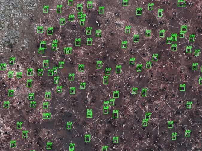
Processing the point cloud and the mesh makes it possible to distinguish the penguins from the terrain features such as outcrops and also to determine the size of the individual penguins. While the processing of raster images created a validated set of data concerning the number of the penguins in the study area, the dense point cloud data allowed the penguins to be classified into chicks and adults. By working with both products, it was possible to develop a sustainable method for counting and classifying the Antarctic penguins: Chinstrap (Pigoscelis antarcticus) and Gentoo (Pigoscelis papua). Further development of the method may allow classification of other types of penguin as well.
Conclusion
In some way or other, global warming is having a significant impact on every species. In order to improve our understanding of these changes, it is necessary to evaluate sustainable methods for the accumulation of precise data and innovative methods for processing it. The Bulgarian Antarctic Institute has been performing precise photogrammetric surveys using UAVs for several years. Airborne surveying supports further advancement of studies of Antarctica and the gathering of knowledge about places and issues that are not possible using traditional methods.