
Construction sites and, especially, demolition sites are often challenging environments for surveyors. Nevertheless, effective project management and financial control depend on accurate and timely information about the volumes of materials which have been placed, relocated and removed. Conventional surveys to obtain this information are slow, labour-intensive, expose surveyors to danger and can disrupt site operations. Photogrammetry using an unmanned aerial vehicle (UAV or ‘drone’) and the 3Dsurvey software suite offers an efficient, cheaper and safer alternative.
Around a decade ago, three surveyors in Slovenia were building UAVs and developing 3D software to use for their own projects. In 2015 they set up 3Dsurvey to supply their comprehensive software suite for mapping and image processing to other surveyors. As Tomaž Izak, CEO and surveyor, puts it: “I just wanted to spend more time with my wife and kids. Now, my software is helping surveyors all over the world. They love 3Dsurvey because it’s tailormade for them by people who have been in their shoes, in the field, in the mud and dirt, and who know exactly what a modern digital surveyor needs. Our software is also very affordable.”
Case study: a demolition site
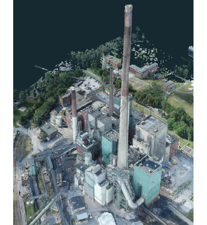
The demolition of a large power station in Germany required effective work progress monitoring, identification of the materials on site, and determination of volumes. The site covered approximately 40 hectares and the buildings had a combined volume of approximately one million cubic metres. Conventional surveying methods would have been extremely time-consuming, exposed the surveyors to a hazardous environment and would not have provided sufficiently detailed data.
The surveying team decided to undertake regular photogrammetric surveys using a UAV (DJI P4RTK), a GNSS receiver (Emlid Reach RS2) and the 3Dsurvey software. The initial survey of the wider area (approx. 2,000 images) was followed by monthly surveys of the demolition area (approx. 1,000 images) to determine progress. For each survey, the positions of several ground control points (GCPs) were determined using the GNSS receiver. Using a UAV with RTK significantly reduced the number of GCPs required. For applications demanding less accuracy, surveys can even be done without any GCPs. Surveyors can use any convenient type of GCP, or dedicated 3Dsurvey GCP targets which are automatically recognized by the software, to save even more time.
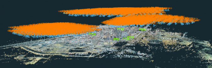
The flight was prepared using 3Dsurvey Pilot, the free app for planning flights with DJI AUVs. If another make of UAV had been used, the flight could have been planned using its own flight planning software.
Image processing
This project used only UAV photographs, but for other applications these can be combined with images from ground-based cameras, Lidar and sonar. After the flight, the photographs were imported into the 3Dsurvey software and linked to the GCPs using the Orientate function. Next, the software generated the point cloud, full 3D mesh, digital surface model (DSM) and true orthophoto. The resolution of the images was high enough for effective identification of the materials to be removed from site.
Measurement and analysis
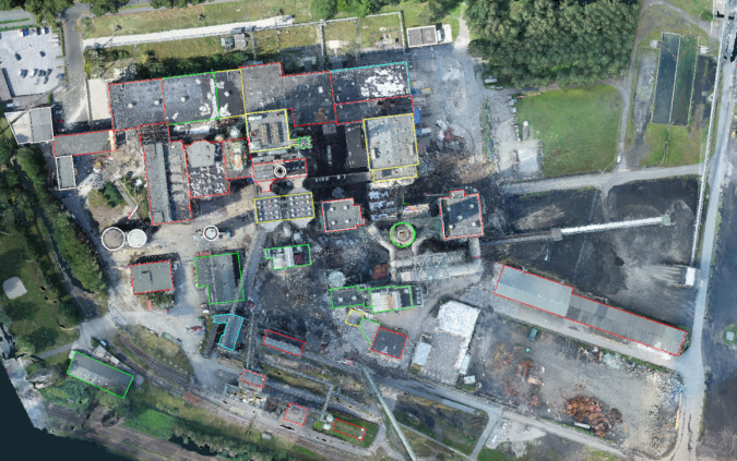
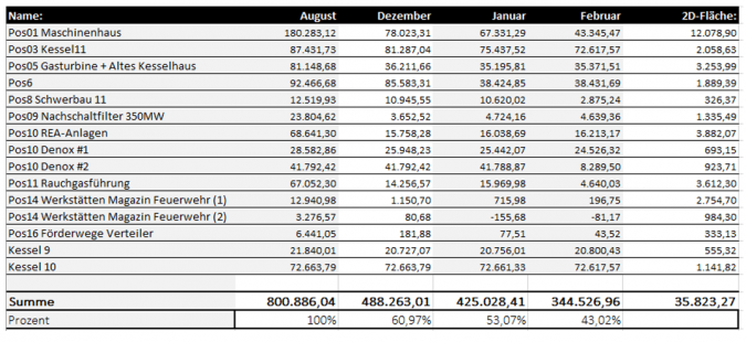
Once the mesh had been created, features such as buildings and heaps of material could be defined and named, and their volume or area calculated. This made it particularly easy to report on the progress of the demolition and waste volumes. 3Dsurvey could also have generated contour maps and site profiles at user-specified intervals. The software has basic CAD functions to draw areas and volumes, which can be exported in DXF and other formats. Undertaking both photogrammetric processing and analysis and measurement within the same software package saved time and costs and reduced errors.
Data presentation and export
The information was presented to the client in a range of formats: a video file with a simulated flight around the site, 2D site plan, 3D model and numerical information to track progress. The 3Dsurvey package exports data in a wide range of file types, such as PDF, DXF, JPEG and TIFF, KMZ for Google Earth, various mapping and GIS formats, and TXT. The client could open the original project file using the free 3Dsurvey Viewer, enabling them to choose from a range of views.
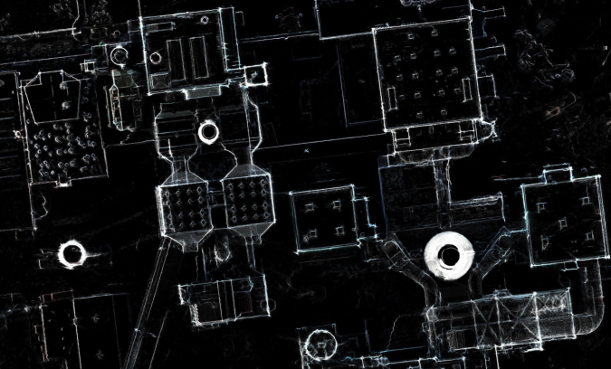
X-ray function looks through roofs
3Dsurvey has a unique feature: the X-ray function. This uses data from a number of photographs taken at different angles to mark wall positions on an orthophotograph, irrespective of the roof overhang. In this way, the volume of the buildings can be determined accurately and drawn with the built-in CAD function. This avoids the need to survey the positions of building corners using conventional methods. The X-ray function can save a lot of time and effort, especially in complex and challenging settings such as this demolition site.
Other applications
Historic buildings and city centres are documented for conservation and planning reasons. Landslides and other active geological features need to be monitored regularly, with great accuracy and without exposing surveyors to danger. The scene of road traffic accidents must be recorded in detail before the road can be opened to traffic again. This often leads to traffic delays when using conventional methods and important details may be overlooked due to time pressure. In all these cases, software such as 3Dsurvey can use input from a range of sources – such as UAV and conventional photographs, laser scans, etc. – to produce digital surface and terrain models, true orthophotographs and basic CAD drawings. These deliverables support a range of applications and can be processed with standard GIS and CAD software. Such photogrammetric surveys take much less time in the field than conventional surveys and offer the surveyor great flexibility back at the office. If the client requests additional data, beyond the original brief, then the surveyor can respond quickly, often without a further visit to the site.
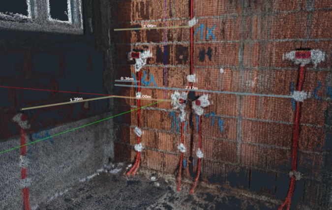
The software has also been used to create 3D models of building interiors and process plants, based on photographs taken with a handheld camera. This makes it possible to acquire the data quickly and at low cost, with a minimum impact on site operations. The models can be marked up with the position of piping and other services to support maintenance planning over the lifetime of the structure.
Open-cast mines, quarries and bulk ore terminals present dangerous environments where there is a need to measure large volumes of material safely and efficiently, without a surveyor walking around the site. This makes them a perfect application for UAV photogrammetry. When surveying a quarry where materials are excavated from a flooded area, 3Dsurvey can combine bathymetric sonar data with UAV photographs. This results in a unified 3D model of the site, showing both above-ground and underwater features.
Licensing and support
The 3Dsurvey software has a relatively low price and is available under a perpetual licence, monthly subscription, and hourly access through GeoCloud, to cater for the needs of both regular and occasional users and surveying businesses of any size. New users also receive one-to-one support online or by telephone, to help them optimize their projects.
The software is supported by extensive tutorial videos and datasets, and dozens of case studies on the developer’s website as well as a recently created user forum. As the package was designed by surveyors for surveyors, the 3Dsurvey workflow feels very natural to most users.
Conclusion
On a demolition site, the combination of a UAV, GNSS receiver and 3Dsurvey software made it possible to complete the initial map, drawings and photographs of the site quickly and safely. This was followed by regular UAV flights to report on the progress of the project. The software provided a range of accurate and valuable project management information at relatively little effort and cost.
More information