How Does It Work, and What Does It Mean for Mobile 3D Mapping?
May 28, 2021
Simultaneous localization and mapping (SLAM) is not a specific software application, or even one single algorithm. SLAM is a broad term for a technological process, developed in the 1980s, that enabled robots to navigate autonomously through new environments without a map.
Part 1: What is SLAM?
How does it work, and what does it mean for mobile 3D mapping?
SLAM 101
Simultaneous localization and mapping (SLAM) is not a specific software application, or even one single algorithm. SLAM is a broad term for a technological process, developed in the 1980s, that enabled robots to navigate autonomously through new environments without a map.
Autonomous navigation requires locating the machine in the environment while simultaneously generating a map of that environment. It’s very difficult to accomplish, because the machine needs to have a map of the environment to estimate its own location. But to generate the map, it needs to know its own location.
As a result of this never-ending circle of dependencies, SLAM was sometimes called a 'chicken or egg' problem.
How does SLAM work?
There are many approaches to SLAM. Luckily, we can still make some generalizations to demonstrate the basic idea.
Here’s a very simplified explanation: When the robot starts up, the SLAM technology fuses data from the robot’s onboard sensors, and then processes it using computer vision algorithms to 'recognize' features in the surrounding environment. This enables the SLAM to build a rough map, as well as make an initial estimate of the robot's position.
When the robot moves, the SLAM takes that initial position estimate, collects new data from the system’s on-board sensors, and makes a new (and improved) position estimate. Once that new position estimate is known the map is updated in turn, which completes the cycle.
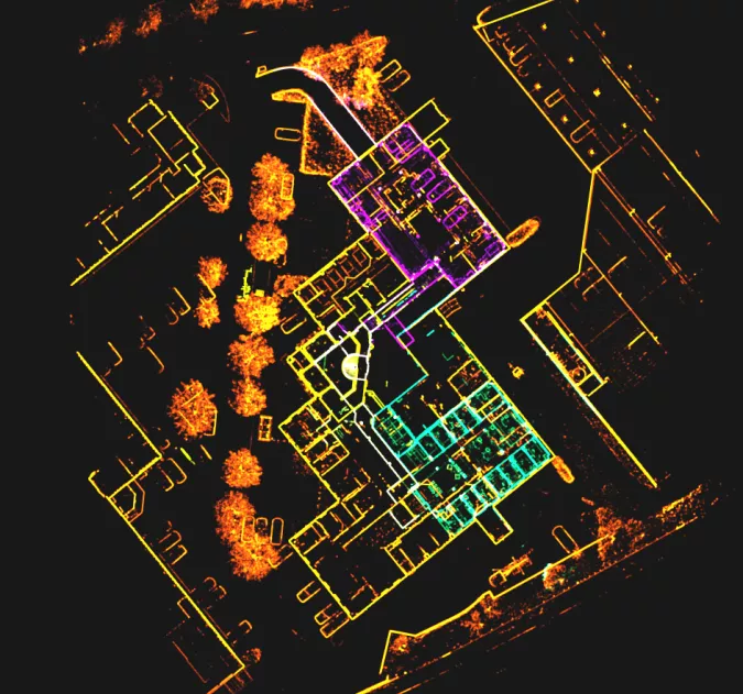
By repeating these steps continuously, the SLAM tracks the robot's path as it moves through the asset. At the same time, it builds a detailed map.
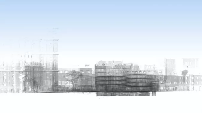
Generating a map
The evolution of SLAM
Due to the rapid growth of computing power since the 1980s – not to mention the availability of freely downloadable code from companies like Google – SLAM is now used in a wide variety of applications. In fact, you’ll see it in virtually every application where a machine requires a live 3D map of its surroundings to operate.
Here are just a few applications that rely on SLAM technology:
Autonomous consumer robotics (like drones or vacuum cleaners)
Self-driving cars
Smartphone augmented reality apps
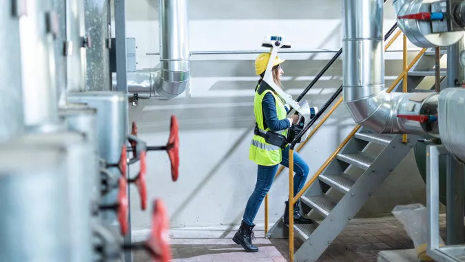
Mobile 3D mapping systems
SLAM and mobile mapping
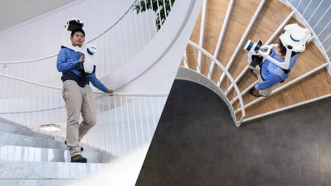
Now we can talk about the application of SLAM most important to us: mobile mapping systems. You can think of these tools as laser scanners designed to offer the best possible building documentation workflows.
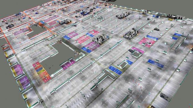
Mobile mapping systems use a combination of highly calibrated sensors and SLAM technology optimized for mapping. These tools enable you to capture 3D point clouds and panoramic images as you walk. They offer fast, comprehensive documentation for large assets and complex environments like factories work sites and offices.
You might also see these devices referred to as:
Indoor mobile mapping systems (IMMS)
Walkaround mobile mapping systems
SLAM laser scanners
But they're all essentially the same thing.
These devices are not to be confused with another kind of mobile mapping system, however, which mounts on top of a vehicle for large outdoor capture projects.
SLAM is the 'secret sauce' that enables the system to work without a tripod.
The SLAM technology fuses data from the sensors on-board the mobile mapping system to track your location as you walk through the asset. You can think of each position on this trajectory as a 'virtual tripod', which the software uses during the processing stage to ensure that each point in the point cloud is in the correct place.
By enabling the development of mobile mapping technology, SLAM has helped us take the logical next step in building documentation technology.
For a long time, building documentation work was performed manually, with devices like theodolites or tape measures. The 1980s saw the first total stations, which capture points much faster and with extremely high precision. In the 2000s terrestrial laser scanners (TLS) came along and brought the documentation workflow to the next level by capturing millions of points instead of only one at a time.
In 2015, the first mobile mapping systems using SLAM appeared. They offered another step forward – they can capture millions of points while the operator moves, so they are no longer confined to a dedicated position like TLS are. As a major bonus, they also include RGB cameras that capture 360° photography with no extra effort.
RAPID CAPTURE
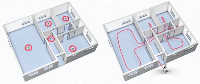
A TLS workflow can require setting up your scanner dozens of time for a single project (maybe hundreds, if the asset is particularly large). Mobile mapping eliminates this step, speeding up the workflow significantly. In typical projects, we've seen a speed increase of 10x or more.
FASTER REGISTRATION
Since a TLS captures only a small area at a time, you’ll need to connect the scans to produce a final point cloud. You can accomplish this by overlapping your scans, which slows you down since it limits the distance you can move the TLS to the next station. Or, you can use survey targets, which is complex and increases the time spent on site.
A mobile device scans continuously – in some cases capturing up to 3,000 square metres – before you need to start another scan. This means less work to ensure full coverage.
COMPREHENSIVE DATA
Since any laser scanner can capture only what’s in its line of sight, a TLS requires that you move the device to a new setup if you want to scan past an obstruction and avoid blank spots in your data. A mobile device enables you to walk around an obstruction, fill in your capture and be on your way.
INTUITIVE, PHOTOREALISTIC DOCUMENTATION
The best mobile mappers use the combination of Lidar and RGB cameras to capture a densely coloured, photorealistic 3D dataset of the building. These walkthroughs are intuitive to navigate, explore and measure, even for stakeholders who are totally unfamiliar with point clouds.
REAL-TIME FEEDBACK
Leading mobile mappers with a tablet display will show you the quality of your capture as you work, offering real-time feedback on your scan. Miss a spot? The screen will show you, so you can immediately make a correction.
Part 2: Mobile mapping vs terrestrial laser scanning – comparing workflows and how they meet your project requirements
To illustrate the benefits of SLAM and mobile mapping systems, let’s look at how it performs compared to a TLS while documenting a typical office environment.
Below you’ll see an illustration of the setups you'd need to capture this complex space using TLS and target-based registration. Add extra setups in each of the door frames for cloud-to-cloud registration (unless you want to spend the time to set up targets). Add extra setups if there are furnishings obstructing your scanner’s view, and even more setups if you wanted to capture the fine details of features like window frames.
At the fastest, you could scan this space in about 20 minutes with a TLS, but given the extra factors we listed above, you can see how it would likely take longer than that.
Using a mobile mapping workflow, you could ditch the tripod and just walk through the space as necessary to capture. You can move fast and still be sure that you’ve captured everything you need.
TLS vs Using a mobile mapping workflow
What it can do for your business
By enabling the fast, flexible workflows we covered above, SLAM and mobile mapping systems can have long-reaching effects on your business. Adding a mobile mapper to your toolset can help you to keep your existing clients and gain new clients, all to help your business grow.
IMPROVE EFFICIENCY
Finish bigger projects at less cost and take on more projects with your existing workforce.
REDUCE CLIENT DISRUPTION
Get in and out faster. Reduce the amount of downtime required for your scan and win new clients in sensitive industries like healthcare, manufacturing and more.
EXPAND SERVICES AND OFFERINGS
Start offering fully immersive 360° walkthroughs generated by your mobile scanner. Make your list of services more compelling than your competitors' offerings.
INCREASE FLEXIBILITY
Meet the needs of price-sensitive customers by producing high-quality datasets at a low cost.
SHARPEN COMPETITIVE EDGE
By improving your efficiency, flexibility and services as well as reducing disruptions to your clients, you’ll make your business stand out from competitors.
Now that you understand the basics of SLAM and mobile mapping systems, you likely have some in-depth technical questions. We answer the most common questions below.
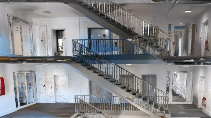
SLAM X-Ray Scan
What technical terms do I need to know to understand mobile mapping?
We’ve put together a short glossary that you can read here, it explains all the technical terms in plain English.
How accurate is a mobile mapping system?
The simple answer: The best systems reliably produce data that is more than suitable for as-built documentation needs. In one case study, we tested our own NavVis VLX by performing a single scan in a parking garage. With the application of loop closure for error correction, the team validated the data at 8mm absolute accuracy, to one sigma. With the loop closure AND control-point optimization, the absolute accuracy improved to 6mm.
That means you could confidently use the data for projects like LOD 300 BIMs or floor plans with a scale of up to 1:50.
The more complicated answer: The absolute accuracy of a mobile mapper is very complicated to define with a single number. This is because they process the final point cloud using SLAM technology – and SLAM performance varies depending on numerous real-world factors, such as the geometry of the environment you’re scanning. (This is why you often see absolute accuracy numbers listed on spec sheets as a range – for instance, 6-15mm.)
Before a vendor can make generalized statements about the accuracy of any given mobile mapper, they will have to perform extensive testing, in a variety of scenarios, and see how the system works in each of the real-world scenarios where it would be used.
Why do some SLAM systems perform better than others?
If you lined up three systems with identical form factors and sensor payloads, you could still expect the systems to return results that vary significantly in quality. Why is this?
It comes down to the quality of the SLAM implementation. Here are two of the primary factors that set one SLAM system apart from another.
ROBUSTNESS
In the real world, SLAM systems will find some environments more challenging than others. Here’s a good example: A long hallway with minimal doorways lacks the features that the SLAM needs to track your position. This can cause errors in the trajectory data generated by the SLAM and degrade the accuracy of the final point cloud.
More robust SLAM can handle more of these types of situations and handle them better. They produce a better trajectory and, in turn, more accurate final point clouds.
ERROR CORRECTION
The environment isn’t the only thing that can create errors in a mobile dataset. Errors also come from the sensors themselves. All sensors produce a certain amount of noise, which can add up to tiny deviations in the SLAM estimate. Over time, that accumulates to a problem called drift.
That’s why virtually every scanner on the market offers features that correct errors and improve the accuracy of your final dataset.
However, not all SLAM systems are created equal in this regard. Most of them offer loop closure, which corrects for errors when you return to a spot you’ve already scanned. But not all loop closure technology will produce the same results. And some systems offer control-point functionality for locking the trajectory data to surveyed control points, but most do not.
In short, some SLAM systems have been designed to handle the complexities of real-world scanning better than others. This difference shows clearly in the results.
Why do some SLAM systems process data faster than others?
It comes down to computing power.
As discussed above, a SLAM mapping system fuses data from a variety of sensors to produce a point cloud. The list includes IMUs that track the device’s orientation, HD cameras that snap large, colourized images, and multiple Lidar units that record 300,000 points (or more) a second.
The challenge here is that the sensor payload produces a huge amount of data - too much for the computer in a mobile device to process easily.
As a result, each manufacturer needs to pick their priorities for data processing. Some design their devices to generate point clouds in real time and compromise on quality. Others choose to process the data more slowly, but produce higher-quality results. Another group gives you the option to select real-time processing or higher-quality processing, depending on the needs of your project.
NavVis has chosen yet another approach. The company’s mappers process data while you scan to display real-time visual feedback on your tablet. Then, they use more powerful computers back in the office to finalize the data and produce point clouds of the highest quality.
How can the SLAM system produce a point cloud more accurate than the sensor is specified for?
Because a mobile scanner captures continuously as you walk.
Whereas a terrestrial scanner captures each measurement point once during a scan, a SLAM system automatically captures each measurement numerous times, from multiple angles, as you move through the asset.
This gives the post-processing software a large set of possible x, y and z values for each point. It performs complex analysis on these values, enabling it to reduce or even eliminate uncertainty that arises from physical phenomena like sensor noise.
The result? It can produce a point cloud that is more accurate than the sensor is specified for.
Mobile mapping technology is changing fast. How do I know my device won’t be obsolete as soon as I buy it?
A SLAM device is a lot more than its hardware; it relies heavily on software to produce a final point cloud. By updating and tweaking that software, a manufacturer can upgrade your device long after you’ve made the initial purchase.
Some vendors continue to develop their software to make improvements to SLAM processing, live visualization and the quality of their post-processing. They release these improvements as software updates, so you can simply download and install them on your device or your computer to upgrade. Voila: you now have the latest technology.
What are the benefits of post-processing my point clouds using computer or cloud-based software, instead of using the computer on my mobile mapper?
When you use computer or cloud-based software for post-processing, you gain the advantage of significantly more computing power. That means the tool can take more time, perform much more intensive processing, and produce better results.
NavVis’ post-processing software, for example, applies sophisticated filters and treatments to perform more realistic colourization and texturization, more effective noise reduction and better surface reconstruction.
It also uses this extra computing power and time for another advantage: it offers unique processing features like removing the 'ghosts' of dynamic objects, cleaning the fringe points that can affect edges, and so on.
The result of all this more intensive processing is a point cloud that is crisp, low noise and more subjectively 'beautiful'. The difference in quality should be obvious with even a cursory review.
Download this article as a print friendly PDF and receive our weekly overview of the most important geomatics news and insightful articles and case studies.
Sharing this article
Ofcourse we encourage you to share this article with your peers if you enjoyed reading it. Copy the URL below or share it on your social media of choice.
This site uses cookies. By continuing to use this website, you agree to our Cookies Policy. Agree