
Don Cummins is passionate about agriculture and flying, which inspires the Air Data Solutions (ADS) President, to deliver real workable data from aerial photography missions. The company began by providing simple aerial photography to farmers and land owners for property management and has developed into offering more sophisticated data acquisition services, such as 4-band imagery, to natural resource, and oil and gas stakeholders. Don understands that improving image quality and processing efficiency, by investing in aerial systems, is key to growing his business and opening up opportunities previously out of reach.
(This article is brought to you by Phase One Industrial)
"We needed a complete turnkey aerial imaging solution, compact in size and weight and flexible enough to be able to use our current fleet of aircraft, improve productivity, and ultimately bid on bigger projects”, Don Cummins, President Air Data Solutions.
Improving Efficiency, Reducing Workload
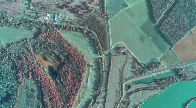
In 2018 ADS was appointed by Total Midstream Integration (TMI) to capture data of oil and gas midstream pipelines. Aerial images were to be used to determine right of way mapping and wetland identification for pipeline installation and maintenance. The combined NIR and RGB aerial imagery from the 4-band solution would be used to plan routes, identify structures along the ROW, and assist in identifying vegetation stress, which could indicate oil and gas leaks.
In the beginning Cummins used DSLR cameras to capture survey data, but he soon realized that he needed to offer better quality images and that the current technology was not able to produce his required results. In order to meet customer demands and maintain the use of ADS’s current fixed-wing platform, he needed a solution that would improve productivity, reduce hours in the air and increase image processing speed. His search began for an aerial system that offered a larger format sensor for high-resolution images, easy installation into the current ADS fleet of aircraft, and compatibility with his existing platform. In addition, Don wanted to improve flight efficiency with better planning and flight management systems.
“We understood the need to invest in a more robust, flexible system but wanted to ensure continued use of our current fleet of aircraft to enable the lower flight altitude and lower operating costs compared to those of other larger aircraft, whilst still maintaining sharp images at efficient speeds. The compact size and weight of the Phase One Industrial cameras allowed us to do just that” says Cummins. “Phase One Industrial’s software also impressed us. iX Plan and iX Flight provide the additional resources needed to manage and guide the precise execution of our aero-photography missions and further reduce pilot and operator workload”
From Flight Planning to Image Processing – A Complete Solution
Don identified Phase One Industrial’s 100 megapixel Aerial System (PAS) as the best solution to meet his requirements, offer a quick return investment, and fit on ADS’s current fixed-wing platform. Phase One Industrial’s iX Plan and iX Flight software solutions further increase productivity. iX Plan generates effective flight plans by automatically calculating flight lines and trigger points based on information fed into the program such as: sensor and project parameters and mapped terrain height. iX Flight then presents the pilot with altitude and localizer direction to enable easy interception of aero-photography lines, while the operator manages the flight, controls the order of passes, tags images and starts and stops image collection.
“The 100MP system offers a turnkey all-in-one solution with the flexibility we need with a favorable price point. Best of all we are able install and fly it in less than two days” Cummins explains. “Phase One Industrial cameras offer much larger CMOS sensors that have high sensitivity. Medium-format gives us flexibility, fast captures rates and ultra-high resolution while iX Plan and iX Flight together manage and guide us through the precise execution of aero-photography flights”
“We can fly faster and lower in most light conditions, we have actually flown missions down to as low as a 2 degree sun angle and were able to produce acceptable images for visual analysis. We have fewer flight lines for corridor mapping, and reduce our time in the air.” Don Cummins, President Air Data Solutions.
In August 2018, ADS installed their first PAS system into their fleet. Phase One Industrial was on site to oversee the process. Luis Viveros, Phase One Industrial Sales, was able to provide onsite training on iX Flight plan, iX Flight and iX Capture which helped Don and his team overcome the challenge of learning new systems.
Surpassing Expectations
“Phase One Industrial really exceeded our expectations. The system was less complicated to install than I had initially thought. I was able to fly a mission on the same day and we had Luis on site to assist us throughout the installation.” Cummins continues, “We entered flight parameters in iX Plan, which created optimal flight lines. On board, iX Flight helped to maintain exact directory and improve data collection.
The flight for TMI surpassed expected planned flight hours and turnaround time. With a bigger ground coverage from the system, in just one pass, ADS delivered higher quality data with less than half the previous processing times.
“Best of all,” says Don, “We were now able to also collect 4-band data for TMI this in one flight, when previously they could only supply 3-band. Our new aerial system holds two cameras in 4-band configuration, which we use to capture data NIR and RGB data.”
Data collection of a 100,000 acre area took around 3 hours to complete at a flight altitude of 3500 feet and provided a ground sampling distance (GSD) of 4 inches. A similar project in the previous year using the old DSLR camera system took 8 hours to complete at a lower altitude of 3000 feet and provided a GSD of 6 inches. The PAS 100 has an ISO of 50-6400, with an amazing dynamic range of 83dB which means longer flying hours and if necessary, in poor light conditions, still providing perfect imagery.
After landing, data is easily processed into georeferenced industry standard formats. iX Capture provides outputs in different industry standard formats; 4band TIFF, CIR, NDVI or others to meet end-user requirements. The PAS supports one pass with multiple deliverables.
Takeaways
Adding Phase One Industrial aerial systems enabled Air Data Solutions to:
- Produce high quality data in a much quicker turnaround time.
- Collect data for numerous projects in one flight
- Reduce flight and image processing times by more than half.
- Lighten crew workload.
- Offer 4-band solutions which gives the resources and capacity to bid on bigger projects.
ADS is now looking to integrate Phase One Industrial cameras into aero-photography applications such as UAVs for mapping, surveying and inspection.