
Blue Marble Geographic’s flagship software, Global Mapper Pro, is an all-in-one GIS package for analysing and processing vector, terrain, image and point cloud data. Compatible with over 380 different file formats, Global Mapper can be seamlessly brought into existing workflows. In version 25, new updates to the software include a new automatic point cloud analysis tool, the ability to position an optimal flattened site plan, plot the least cost path across a landscape, image painting, use vector features in watershed analysis, and significant improvements to the processing speed in pixels to points.
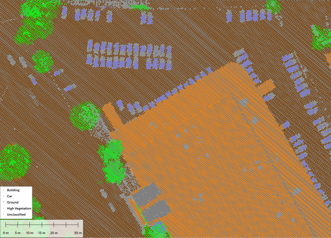
The segmentation tool in Global Mapper’s Point Cloud Analysis system is extremely useful for dynamically classifying points based on existing attributes. Imagine being able to train Global Mapper to look for similar features in other point clouds. Global Mapper’s existing automatic classification tools cover the most commonly classified point structures, such as ground, buildings, poles and more. The new Custom Feature Classification tool lets users define custom classifications based on user-created training samples. They can now create their own automatic point cloud classifications to find unique objects in their point clouds.
Training a custom point cloud classification tool
Segmentation finds objects in a point cloud by looking at the attributes and structure of the points. For example, to segment paint stripes on the road, users would look for points that make up a flat surface, have the same colour, etc. This method operates on the assumption that each ‘object’ in the point cloud, each cluster of points, has a signature made up of attributes and/or structures that separate it from its neighbours. The new Custom Feature Template tool takes advantage of these signatures so that a custom classification tool can be trained to look for a specific signature in the point cloud.
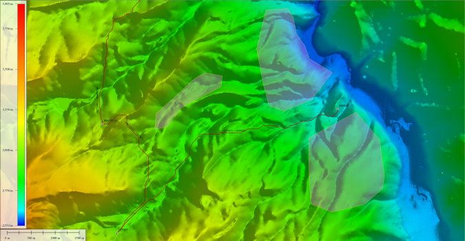
Conducting least-cost path analysis
Forging a new path across terrain often requires navigation around existing structures and difficult areas. New in Global Mapper version 25, the Least Cost Path tool provides a terrain analysis method for finding the shortest and most efficient path between locations. By iterating through all possible options, it identifies the best route between specified point features across a terrain layer based on minimized terrain slope angle and avoiding unwanted areas. This simple tool can connect multiple locations into a single path, avoid existing structures or discover the most accessible location. This tool is a quick and easy way to avoid the pitfalls of poor road planning, such as when planning roads through a construction site.
Generating a photogrammetric point cloud
Pixels to Points is a photogrammetric processing tool within Global Mapper Pro that creates photo-textured 3D models, orthoimages and high-resolution point clouds via Structure from Motion (SfM) and multi-view stereovision. Using overlapping images collected using an uncrewed aerial vehicle (UAV or ‘drone’), these generated data models can be used in Global Mapper to measure terrain volume, asses structures, create detailed base maps and more. The new version 25 release improves the Pixels to Points tool, including significant speed advancements to decrease the processing time and revisions to the Input Wizard to further streamline workflows.
The Pixels to Points Input Wizard is designed to increase ease of use for existing users and to make photogrammetric processing more approachable for new users by streamlining settings choices. Users can simply import their images and choose their most important output, including the option to run a quick output for quality assessment. Global Mapper adjusts the Pixel to Points settings to match the input, providing an optional follow-up option to tweak the settings if desired. They can also use the primary dialogue to add control points and assess more advanced settings such as masking and colour harmonization. With Global Mapper Pro’s powerful point cloud processing tools, Pixels to Points provides a powerful and streamlined option for creating and editing spatial data.
Automatic search for the optimal location for the Flattened Site Plan
Create a Flattened Site Plan is a popular tool for preplanning the best location, elevation and required earthworks for the creation of a flat surface in a terrain layer. As a new option in the tool, Create an Optimal Flattened Site Plan can take advantage of any flexibility in the exact placement and orientation of the flattened site. Global Mapper assesses the terrain in a specified location to find the optimal placement and orientation for the site that requires the least amount of earthworks. Once the optimal site has been calculated, the tool will provide measurements of the soil volume to be added or removed to create a level surface and a break-even elevation. The flattened site plan and other volume tools optimize the cut-and-fill values and even out the landscape into a flat surface using only the soil on site, minimizing soil or fill transportation costs.

Explore the features in a free trial
Whether users are working with Lidar data, complex terrain surfaces, vector features or looking to streamline workflows with Python, Global Mapper Pro can significantly improve their workflow. To explore all the features available in Global Mapper Pro 25, download a free trial today at bluemarblegeo.com.