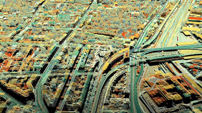
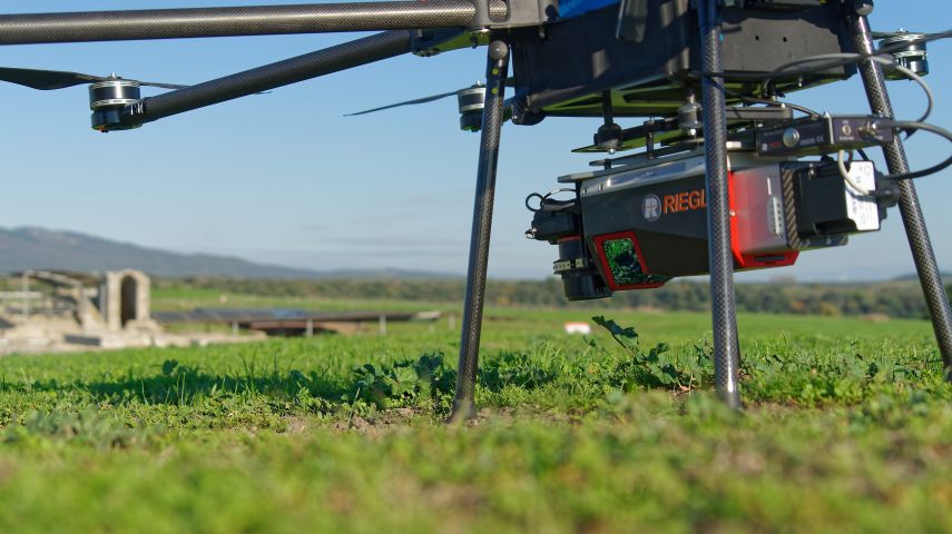
RIEGL VUX-240 Versatile Airborne Laser Scanner
The versatile RIEGL VUX-240 is ideally suited for high point density corridor mapping applications....
RIEGL is a leading international provider of cutting-edge airborne, mobile, terrestrial, bathymetric and UAV-based laser scanning technology for a wide range of applications in surveying. In addition to the headquarters in Horn, Austria – where research & development as well as production are also located – RIEGL provides sales, support and service through its offices in Vienna and Salzburg, the RIEGL USA headquarters in Winter Garden, Florida, subsidiaries in Japan, China, Australia, Canada, and UK and its worldwide network of distribution partners.

RIEGL has been producing LiDAR systems commercially for more than 40 years and focuses on pulsed time-of-flight laser radar technology in multiple wavelengths. RIEGL’s core ‘smart waveform’ technologies provide pure digital LiDAR signal processing, unique methodologies for resolving range ambiguities, multiple targets per laser shots, optimum distribution of measurements, calibrated amplitudes and reflectance estimates, as well as the seamless integration and calibration of systems. RIEGL’s various 3D scanners offer a wide array of performance characteristics.
The professional advice of the RIEGL experts ensures that each customer finds the optimum solution for their specific applications. From initial purchase to system integration as well as training and support, RIEGL stands out as an industry leader.


The versatile RIEGL VUX-240 is ideally suited for high point density corridor mapping applications....

The new "3D Voxel Analysis" software module, available with RIEGL’s proprietary software packa...

The ruins of the mediaeval castle Gars in Lower Austria were documented in an extensive surveying ca...

Explore the RIEGL VMX-RAIL, a revolutionary triple scanner system especially designed for rail appli...

With the VQ-480II and VQ-580II, RIEGL offers airborne laser scanning solutions for applications such...

Find detailed technical information about the VMX-2HA and view brochures, videos and case studies and compare it with other similar products

Find detailed technical information about the VUX-160²³ and view brochures, videos and case studies and compare it with other similar products

Find detailed technical information about the VQ-840-GL and view brochures, videos and case studies and compare it with other similar products

Find detailed technical information about the VQ-1460 and view brochures, videos and case studies and compare it with other similar products

Find detailed technical information about the VQX-1 and view brochures, videos and case studies and compare it with other similar products

Find detailed technical information about the RiPROCESS and view brochures, videos and case studies and compare it with other similar products
This site uses cookies. By continuing to use this website, you agree to our Cookies Policy. Agree