NOAA OPUS
Since March 2001 the National Geodetic Survey (NGS) has operated the Online Positioning User Service (OPUS) to provide end-users with easy access to the US National Spatial Reference System (NSRS)....
Since March 2001 the National Geodetic Survey (NGS) has operated the Online Positioning User Service (OPUS) to provide end-users with easy access to the US National Spatial Reference System (NSRS)....
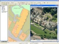
Cadcorp (United Kingdom) has announced a new, free application for viewing Pictometry oblique view imagery within Cadcorp SIS – Spatial Information System. The new Cadcorp SIS Pictometry Viewer, developed by...

Leica Geosystems (Switzerland) has announced IPAS PPP, a new post processing software package within the IPAS product family. It provides high accuracy position and velocity determination using the data from...
Excessive groundwater extraction in the Bandung Basin has led to rapid sinking of the water table and is hypothesised as the main cause of land subsidence. Periodical GPS surveys were...
Hemisphere GPS (Canada) has introduced the new Crescent VS100 and VS110, a heading and positioning solution for machine control and marine navigation applications including dredging and hydrographic surveying. Hemisphere GPS's...

Trimble (CA, USA) has introduced the latest addition to its Mapping and GIS product line; the Juno ST handheld, a portable, low-cost data collection solution supported by Trimble’s range of...
Map Middle East 2007, the third Annual Conference and Exhibition on Geospatial technologies and their applications, was held from 9th to 11th April 2007 at the Dubai International Convention and...
Topcon Europe Positioning and TSD have announced a new family of automated paving control systems. The three new systems: ReadyPave, MasterPave and AutoPave; all feature easy-to-use, automated controls with millimetre...
Each year disasters such as storms, floods, volcanoes and earthquakes cause thousands of deaths and tremendous damage to property around the world, displacing tens of thousands of people from their...
Map Middle East 2007, the third Annual Conference and Exhibition on Geospatial technologies and their applications, was held from 9th to 11th April 2007 at the Dubai International Convention and...
This site uses cookies. By continuing to use this website, you agree to our Cookies Policy. Agree