ScanMaster 2.0
Topcon has announced the release of ScanMaster 2.0 software which is faster and more powerful than previous versions. This new software saves time and increases the productivity on every job,...
Topcon has announced the release of ScanMaster 2.0 software which is faster and more powerful than previous versions. This new software saves time and increases the productivity on every job,...
Navigation is a daily activity for many as they move from place to place. With increasing complexity in transportation networks has come a rising demand for navigational assistance. Over the...
We all know about the rapid evolution in world mapping. While mapping was long the domain of skilled mapmakers, nowadays it is increasingly in the hands of the lay public,...
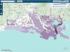
Esri has created a map showing parishes within the Federal Emergency Management Agency (FEMA) 100-year flood zone in Louisiana (USA). FEMA is a government body supporting citizens and first responders...
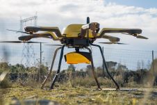
YellowScan, a familiar name in the mapping and land surveying realm, is making a noteworthy entrance in the hydrographic sector with the introduction of its pioneering UAV-based bathymetric Lidar solution....

Jonathan Arthur Quaye-Ballard is a professor and head of the Department of Geomatic Engineering at KNUST, where he has worked for the past 20 years. He also holds a BSc...

Incorporating smart methodologies in cadastral surveying is improving the land acquisition system in Ghana. Traditional cadastral surveying is time-consuming and, if not planned out well, could cost a fortune to...
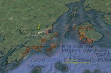
Fugro has tested a multi-sensor approach to balance growing data needs with limited agency budgets. Coastal mapping programmes are quickly becoming a priority for government agencies across the globe. The desire...
This site uses cookies. By continuing to use this website, you agree to our Cookies Policy. Agree