Jonathan Arthur Quaye-Ballard
Jonathan Arthur Quaye-Ballard is a professor and head of the Department of Geomatic Engineering at KNUST, where he has worked for the past 20 years. He also holds a BSc...

Jonathan Arthur Quaye-Ballard is a professor and head of the Department of Geomatic Engineering at KNUST, where he has worked for the past 20 years. He also holds a BSc...

Incorporating smart methodologies in cadastral surveying is improving the land acquisition system in Ghana. Traditional cadastral surveying is time-consuming and, if not planned out well, could cost a fortune to...
Vexcel Imaging GmbH will roll out release 2.0 of its UltraMap photogrammetric software to customers beginning 25th January 2010. UltraMap 2.0 continues the tradition of providing a flexible and scalable...
Pitney Bowes Business Insight (PBBI) has unveiled Stratus Connect 2.0 during GeoCommunity 2009. The new features included in Stratus Connect 2.0 extend the capabilities of the definitive location intelligence tool...
Where2.0Now? is a one-day conference on 10th November 2009, hosted by the Association for Geographic Information (AGI) Northern Group (#AGI_NG) in partnership with the Centre for Spatial Analysis and Policy...
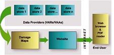
There has been a recent increase in the incidence of major disasters and the damage caused, in terms both of human suffering and economic cost. UNOSAT Mapping The main goal...
TatukGIS has released the 2.0 upgrade of its desktop GIS Editor product with new features such as advanced support for coordinate systems, many new data formats, and scripting for customising...
Satellite imagery provider DigitalGlobe (CO, USA) today released Citysphere 2.0, an enhanced version of its library of on-demand digital satellite imagery of the most populated global cities. CitySphere 2.0 features...
This site uses cookies. By continuing to use this website, you agree to our Cookies Policy. Agree