ScanMaster 2.0 Laser Scanner Software
Topcon Positioning Systems (TPS) has announced the release of ScanMaster 2.0 software which is developed to be faster and more powerful than previous versions. The software streamlines the data processing...
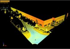
Topcon Positioning Systems (TPS) has announced the release of ScanMaster 2.0 software which is developed to be faster and more powerful than previous versions. The software streamlines the data processing...
Jack Dangermond, founder and president of ESRI is to be one of the keynote speakers at this year's Where 2.0 Conference in San Jose, California, on 1st April 2010. As...
Dr. Walter Scott, founder and chief technology officer of DigitalGlobe, is to present a keynote speech at this yea\'s Where 2.0 Conference in San Jose on 1st April 2010. As...
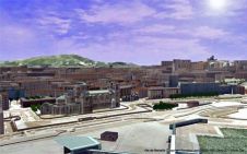
Bionatics has released version 2.0 of LandSIM3D, its 3D smulation and visualisation software dedicated to territory planning and landscape preservation. This version offers new features to answer the growing needs...
Vexcel has launched version 2.0 of the Microsoft Virtual Earth Server, the on-premises intranet mapping platform based on Microsoft Bing Maps for Enterprise (formerly known as Microsoft Virtual Earth). Virtual...
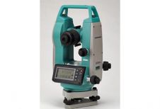
Sokkia is releasing a new digital theodolite series, the DT220, DT520, DT520A and DT620, with as a main distinguishing feature an improved power-saving technology. The DT620, recently set a world...
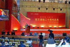
On 8th April 2009, South Surveying & Mapping was celebrating its 20th Anniversary during a grand ceremony in Guangzhou Baiyun International Convention Center. Deputy Director of State Bureau of Surveying...
Get an introduction to Lidar Explorer at one of ProLogic's free January webinars. The two webinars will be held Wednesday, January 9, 3:00 - 4:00 PM EST and Thursday, January...

Amuse oneself Inc., established in 2011, develops hardware and software for 3D measurements required for ICRT technology (Information, Communication and Robot Technology). Since our successful commercialization of the world’s first...

3D visualization is at the heart of many geospatial data applications. Progress in 3D visualization has drastically reduced barriers to entry for new products based on large datasets, thanks to...
This site uses cookies. By continuing to use this website, you agree to our Cookies Policy. Agree