3D geospatial visualization
3D visualization is at the heart of many geospatial data applications. Progress in 3D visualization has drastically reduced barriers to entry for new products based on large datasets, thanks to...

3D visualization is at the heart of many geospatial data applications. Progress in 3D visualization has drastically reduced barriers to entry for new products based on large datasets, thanks to...

The U.S. Geological Survey has contracted with Woolpert to conduct a high-precision geophysical survey and subsurface geologic mapping in Arkansas. The firm will collect, process and deliver high-resolution airborne radiometric...

Septentrio has announced that GeoDuster Technologies, a South Africa-based premium integrator of systems and software built to aid exploration success, has selected the TERRASTAR-D Precise Point Positioning (PPP) service and...
Whenever new objects have to be created, be it on or below the land and water, construction plays a role. The construction process often starts with surveying, either [marine surveying]...

Hydrographic and geophysical survey operations will be undertaken by INFOMAR in the Celtic Sea and the Atlantic Ocean between April and October this year, according to a recent marine notice...
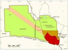
New gravity data obtained in the Woomera Prohibited Area in South Australia has been released. The gravity data was collected by Geoscience Australia on behalf of the Geological Survey of...
The Indonesian Meteorological, Climatological & Geophysical Agency (BMKG) employs SuperGIS Desktop 3.1, using its powerful GIS tools to integrate and visualise a variety of spatial data and statistics about meteorology....

Erich Nau is a researcher at the Norwegian Institute for Cultural Heritage (NIKU), specializing in 3D documentation and geophysical survey techniques for cultural heritage. With a focus on methodological development,...
This site uses cookies. By continuing to use this website, you agree to our Cookies Policy. Agree