Study Finds Volcano Cliffs Can Affect Monitoring Data
New research led by the University of East Anglia (UEA) has revealed that sharp variations in the surface of volcanoes can affect data collected by monitoring equipment. The surfaces of...
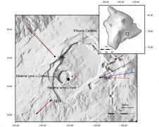
New research led by the University of East Anglia (UEA) has revealed that sharp variations in the surface of volcanoes can affect data collected by monitoring equipment. The surfaces of...
The use of data from Landsat satellites has become a cornerstone of global land imaging with broad societal benefits. More real-time monitoring capability in the future will further our understanding...

Sercel has been awarded a contract by BGP to supply land seismic equipment for a large onshore 3D seismic survey in the Middle East. The contract includes 100,000 Sercel 508XT...

The Remote Sensing and Photogrammetry Society (RSPSoc) conference for 2018 was organised jointly with the National Centre for Earth Observation (NCEO) and the Centre for EO Instrumentation (CEOI) and was...

Since making landfall in the US state of North Carolina on 14 September, Hurricane Florence has caused widespread damage and flooding. The Copernicus Sentinel-1 radar mission is being used to...
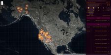
Esri Story Map has released a interactive map can be explored by panning and zooming of the raging fires across the United States providing context to the severity of the...
While 70% of the Earth is covered by water, very little of it has been surveyed so far (Mars, Venus and the Moon are better surveyed). The techniques for doing so...
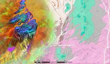
GAF has recently completed an ESA-funded project to support the African Mineral Geoscience Initiative (AMGI). The World Bank-initiated AMGI project is a pan-African initiative for the collection, consolidation, interpretation and...
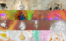
The traditional way of mapping Earth’s geology and mineral resources is a costly and time-consuming undertaking. While satellites cannot entirely replace the expert in the field, they can certainly help...

An increasing number of professionals are discovering that Lidar is the most suitable solution for their needs. Lidar is a sophisticated method of mapping terrain features and man-made structures to...
This site uses cookies. By continuing to use this website, you agree to our Cookies Policy. Agree