GIS4EU
INSPIRE has set a standard towards which GI providers can work and with which GI users can work seamlessly at European scale. GIS4EU has taken this standard and designed a...

INSPIRE has set a standard towards which GI providers can work and with which GI users can work seamlessly at European scale. GIS4EU has taken this standard and designed a...
The Kosmosnimki.Ru website introduces the hybrid view option - map layers over satellite-based image. Now Kosmosnimki.ru enables to handle three view modes: map, images and hybrid. The map overlay is...
Trimble has been selected by three Australian state government organisations to modernise their respective Global Navigation Satellite System (GNSS) infrastructure networks for high accuracy positioning: the Department of Sustainability and...
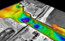
The first commercial airborne Lidar systems appeared on the market in the mid-1990s. This active remote-sensing technology rapidly evolved to become the laser scanners which can today emit 400,000 pulses...
Optech Incorporated, based in Vaughan (Toronto), Canada, virtually brought Light Detection and Ranging (Lidar) to the survey world. Starting as a small R&D enterprise over 35 years ago, Optech has...
The third International and Professional Training Course for Surveyors that took place in Athens, Greece, from 3rd to 14th October 2011 ended with great success and didactic results for the...
HITT NV signed today the Share Purchase Agreement with the owners of IVS 3D. IVS 3D, founded in 1995, has developed highly sophisticated commercial products for marine information visualization, processing...

FIG leaders visited Rome in April 2011 to agree on the programme for FIG 2012 - president Fausto Savoldi, CNGGL, Mika Törhönen, FAO, president CheeHai Teo, FIG, vice president Chryssy...

FIG Commission 3 on Spatial Information Management will organise a Workshop on The Empowerment of Local Authorities: Spatial Information and Spatial Planning Tools from 25th to 28th October 2011 in...
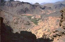
Widening the use of remote sensing facilities will be a boon for the Sultanate's agriculture sector, Khalifa Al Kindi, a Geographical Information Systems (GIS) educator and remote sensing researcher in...
This site uses cookies. By continuing to use this website, you agree to our Cookies Policy. Agree