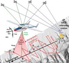
Found 141 results
Sort by

The Fierce Rise of Airborne Lidar

Today, automatic matching of overlapping aerial imagery and airborne Lidar are the main geodata technologies for capturing dense point clouds of the Earth’s surface. The sampled points are used for...

Read more

Multi-sensor Coastal Mapping

Fugro has tested a multi-sensor approach to balance growing data needs with limited agency budgets. Coastal mapping programmes are quickly becoming a priority for government agencies across the globe. The desire...

Read more

Names, Standards and a Competition

Gordon Johnston, chair of the RICS Geomatics Professional Group, reviews recent developments emanating from the Institution. Back in the summer the Global Geomatics Professional Board requested that members vote, offer...

Read more

Smart Cities and Linked Data

The European Union defines a ‘smart city’ as “a city well performing in 6 key fields of urban development, built on the ‘smart’ combination of endowments and activities of self-decisive,...

Read more