Leica FlexLine Total Stations
At Intergeo in Bremen, Leica Geosystems presents a whole new approach to flexibility: they have developed a new generation of Total Stations - the Leica FlexLine. Hardware and software options...

At Intergeo in Bremen, Leica Geosystems presents a whole new approach to flexibility: they have developed a new generation of Total Stations - the Leica FlexLine. Hardware and software options...
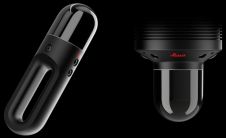
Hexagon AB, a global leader in sensor, software and autonomous solutions, has introduced two additions to the Leica BLK series. The Leica BLK2GO is the smallest portable, completely integrated handheld-imaging scanner in...
Leica Geosystems Geospatial Imaging has changed its name to ERDAS, Inc. As the earth to business company, the new ERDAS product portfolio encompasses the entire geospatial information lifecycle of authoring,...

AVEVA and Leica Geosystems HDS HAVE announced the integration of direct access to Leica TruView laser scan file sets and software within the AVEVA NET Portal. This integration lets AVEVA...
Leica Geosystems Geospatial Imaging (GA, USA) has released Leica Image Manager, an new solution for storing and sharing imagery throughout the enterprise. This solution addresses problems universal to many geospatial...
Terrestrial laser scanning combines a high level of detail with surveying accuracy for the creation of 3D-models of virtually any object. The technology literally opens up new dimensions and so...
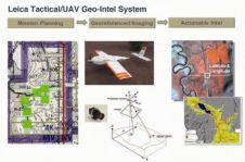
Leica Geosystems Geospatial Imaging (GA, USA) has development a new Tactical Airborne Mapping Surveillance (TAMS) system. TAMS is platform agnostic, with a multi-sensor payload capable of in-theater fixed wing, helicopter...
Leica Geosystems Geospatial Imaging (GA, USA) has enhanced Leica TITAN by adding Microsoft Virtual Earth 2D and 3D Support. Using Leica TITAN's Geospatial Instant Messenger you may now directly publish...

Leica Geosystems (Switzerland) has released verion 2.1 of Leica MobileMatriX a multi-sensor GIS solution for capturing high-accurate GIS data directly in the field. The new version has the ability to...

Leica Geosystems (Switzerland) has announced Leica ScanStation 2, in which the maximum instantaneous scan speed is 50,000 points/second, more than 10-times that of its ScanStation predecessor (4,000 points/second). Leica ScanStation...
This site uses cookies. By continuing to use this website, you agree to our Cookies Policy. Agree