Reflections on HxGN LIVE Global 2023
It is time to innovate with technology that can be applied ‘right here, right now’. That was the clear message during HxGN LIVE Global 2023. President and CEO Paolo Guglielmini...

It is time to innovate with technology that can be applied ‘right here, right now’. That was the clear message during HxGN LIVE Global 2023. President and CEO Paolo Guglielmini...

3D Repo has achieved a Premier Award from the Chartered Institute of Building (CIOB). Celebrating achievement across the built environment, CIOB International Innovation and Research (I&R) Awards are open to...

We invite you to submit abstract for FIG Working Week 2024 in Accra, Ghana. The overall focus will be on Resilient Environment and Sustainable Resource Management, hereunder the role of...
Advanced Navigation has unveiled an expansion of its Boreas digital fibre-optic gyroscope (DFOG) range with the introduction of the new A Series. This development showcases the company’s commitment to meeting...

Geomares Publishing is pleased to announce the release of Spill International, the international website and newsletter on the prevention, preparedness for, response to and restoration of marine spills and pollution,...

DJI, a leader in civilian drones and aerial imaging technology, has signed a Memorandum of Understanding with the Polytechnic University of Turin, Italy, in order to establish an official partnership...

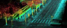
The University of Bradford has taken delivery of the UK’s first Leica TRK700 Evo – a vehicle-mounted mobile mapping system capable of capturing two million data points every second to...
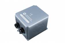
Ordnance Survey, the national mapping agency for Great Britain, was in need of a faster and more cost-effective way to collect georeferenced point cloud data, because the existing method was not sustainable in the long term. The Ordnance Survey team turned to Datron Technology and OxTS to help them develop a convenient, low-cost, ‘off-the-shelf’ mobile mapping system. Ordnance Survey, the national mapping agency for Great Britain, was in need of a faster and more cost-effective way to collect georeferenced point cloud data, because the existing method was...
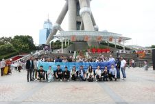
From 5-9 June, ComNav Technology's Annual Partner Conference 2023 took place in Shanghai, China. Some 30 global distributors from the UK, Japan, Australia, Guyana, Uganda and other countries gathered to...

In the early days of surveying, surveyors were pioneers in charting the unknown. Today, with the Earth having been completely mapped to some degree, surveying has become a much more...
This site uses cookies. By continuing to use this website, you agree to our Cookies Policy. Agree