Illuminated Survey Target
Omni Optical Products, Inc. (CA, USA) has introduced their new series of illuminated survey target, the Omni’s 4700 Series Illuminated Target. The target utilises the same backlight technology as in...
Omni Optical Products, Inc. (CA, USA) has introduced their new series of illuminated survey target, the Omni’s 4700 Series Illuminated Target. The target utilises the same backlight technology as in...
The Intergeo congress and trade-fair has now been held a dozen times and the event once again this year demonstrated an exceptionally flourishing geomatics business. Geomatics is all about improving...
GAF AG (Germany) has completed the main phase of a technical assistance project in establishing the geoscience and mining information centre in Madagascar BPGRM, under the “Projet de Gouvernance des...
CEOP (Coordinated Enhanced Observation Period) is currently working on an integrated global water and energy-cycle observation system for scientific and civilian use. One challenge is the creation of a satellite-data...
The development of GIS and carto-graphy can be characterised as information rich and knowledge poor. That is, the amount of geospatial information collected using geospatial technologies, including remote sensing, global...
Core geo-demographic data in a GIS-compatible format derived from decennial US censuses has greatly benefited marketers, social scientists and governments. It has also inspired development of similar datasets in other...
Over recent years the geo-community has used advances in hardware, software and memory to develop software for visualising remotely sensed data. Its 3D nature and capability for integration with other...
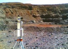
3D Laser Mapping (United Kingdom) is helping Kumba Iron Ore to improve the safety of iron ore extraction in South Africa. 3D Laser Mapping has supplied and installed a Riegl...
Geosoft Incorporated (Canada) is collaborating with ESRI (CA, USA) to deliver integrated software and data management solutions for the global mining and geosciences sector. The collaboration will result in a...
The surveying profession in Australasia is on the cusp of a ‘skills crisis’, there being far too few skilled personnel to fill the many jobs available. For some professionals this...
This site uses cookies. By continuing to use this website, you agree to our Cookies Policy. Agree