Pix4D
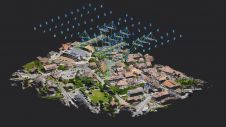
Drone software for optimal aerial monitoring and surveying Pix4D photogrammetry software allows the mapping of medium to large areas faster, saving a lot of time and facilitating the acceptance of...
Drone software for optimal aerial monitoring and surveying Pix4D photogrammetry software allows the mapping of medium to large areas faster, saving a lot of time and facilitating the acceptance of...

Fujitsu has presented a pioneering technology that harnesses Lidar and AI to capture high-resolution 3D data of organisms, coral reefs and man-made structures such as offshore wind turbines using autonomous...

Looq AI has announced the launch of its groundbreaking AI-enabled digital twin technology, the Looq platform. Positioned as a one-stop solution, it allows surveyors, engineers, contractors and asset owners to...
Pix4D has introduced OPF, a new standard for exchanging photogrammetry projects. OPF is a fully open and free specification, enabling the storage and exchange of photogrammetric data among different parties...

Pix4D, Switzerland, has announced the release of version 2.2 of its Pix4UAV desktop software. Pix4UAV is a software package that combines thousands of aerial images taken by lightweight flying platforms...

The Earth observation industry seems to be on a slow burn – but why? Brace yourself for a ‘rollercoaster ride’ through Earth observation as this article unravels the mysteries behind...

MicroSurvey and Pix4D have entered into a global partnership which will provide end-to-end solutions to a wide range of customers. By combining products and competencies, the companies bring expert solutions...
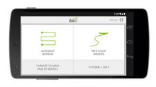
Making use of DJI’s new DJI Phantom software development kit, Pix4D has developed the first mapping app: the Pix4Dmapper mobile app allows drones such as DJI Phantom 2 Vision to...
Pix4D, Switzerland, has agreed on a CHF2.4 million investment from the Parrot Group to accelerate the development of its successful Mapping and Geographical Information System (GIS) software for Unmanned Aerial...
3D TARGET was founded as a trading company and official distributor of non-destructive measuring instruments. In 2016, we created an internal R&D division dedicated to system integration and designed a...
This site uses cookies. By continuing to use this website, you agree to our Cookies Policy. Agree