Web GIS Improves Lidar Collection Response Time
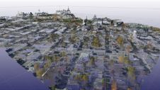
The remarkable capabilities of airborne Lidar continue to improve, with scanners now able to emit more than a million pulses every second. Although it has never been easier to acquire...
The remarkable capabilities of airborne Lidar continue to improve, with scanners now able to emit more than a million pulses every second. Although it has never been easier to acquire...

Imagine a world in which high-speed internet is available everywhere, writes Wim van Wegen in his latest column. Perhaps you’ve just ticked skydiving in the Grand Canyon off your bucket...

Tomas Sandström is business area manager at Adtollo, developer of software for surveying, mapping and design such as Topocad and TopoSurv.
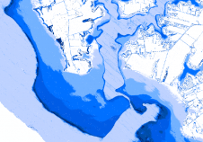
For 227 years, Ordnance Survey’s role has been to create usable representations of the landscape to respond to the changing needs of our customers. We map physical aspects of the...
The remarkable capabilities of airborne Lidar continue to improve, with scanners now able to emit more than a million pulses every second. Although it has never been easier to acquire...

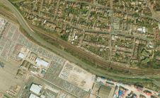
Mapping the underground is one of the major challenges in creating an infrastructure map at the municipal, regional, and national level, which is a key foundation for a national digital...

Whenever anyone talks about Lidar technology in the geospatial sector, it is only a matter of time before the name RIEGL is mentioned. Thanks to its renowned R&D department, the...
New technologies are disrupting the geospatial industry, enhancing productivity and adding new dimensions to the value of geo-information. However, it is the implementation of this technology that often determines whether...
The new version of the Virtual Surveyor drone surveying software now offers a faster, more efficient workflow and better overall user experience in a more stable platform. These new capabilities,...
Ontario-based software vendor Arvizio has announced an update to MR Studio, its flagship product for enterprise mixed-reality. Previously, the application offered visualisation of complex 3D models (including point clouds from your...
This site uses cookies. By continuing to use this website, you agree to our Cookies Policy. Agree