Océ Introduces CrystalPoint Color Technology
Océ has introduced CrystalPoint technology. This new technology combines the best of both toner and inkjet printing. The Océ CrystalPoint process converts color Océ TonerPearlsTM toner into a gel. This...

Océ has introduced CrystalPoint technology. This new technology combines the best of both toner and inkjet printing. The Océ CrystalPoint process converts color Océ TonerPearlsTM toner into a gel. This...
Microsoft and ESRI together are driving Homeland Security innovations to more effectively help protect citizens, prevent and solve crimes, and enable counter-terrorism through software. The newly formed collaboration will combine...

North American cities have been documented at speed using StreetMapper, using vehicle mounted laser scanners to capture highly detailed and accurate measurements at speed. The technique was developed and supplied...
New Tech Services (TX, USA) and Flotron(Switzerland) have released the latest version of the flight planning tool TopoFlight. Many user-requested enhancements have been added to simplify the use. It also...
MapText, Inc (NJ, USA) has introduced its new line of affordably priced integrated labeling software for various GIS systems - GeoMedia, ArcGIS, and MapInfo. These products share the same labeling...
The Grontmij and INPHO Consortium (The Netherlands) has been awarded a Noord Brabant tender for intergrated photogrammetric and land survey processes. The tender covered the modernisation of existing software applications...
Topcon Europe Positioning (The Netherlands) has released Top Field, a new data collection software for their total stations. TopField can be used as an alternative to the standard software on-board...
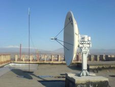
A Russian space data ground receiving station has been installed in Armenia. Small-size universal UniScan complexes, developed and manufactured by ScanEx Research & Development Center, have been used in 40...
Trimble has announced that it will hold its International User Conference February 23-25, 2009 at the Mirage Hotel in Las Vegas. The theme of Trimble Dimensions 2009: Positioning for Success...

TopoSys GmbH (Germany) has founded a new subsidiary located in Denver, Colorado, called TopoSys North America Inc. It serves as a sales and support center to the American, Canadian and...
This site uses cookies. By continuing to use this website, you agree to our Cookies Policy. Agree