Topcon’s Elite Show at Olympic Park
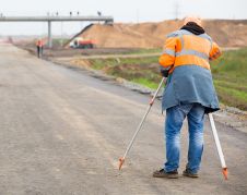
GW recently saw how Topcon’s Elite software suite integrated with the company’s latest hardware. The venue was next to the structural steel eyesore, or elegant sculpture, depending on your point...

GW recently saw how Topcon’s Elite software suite integrated with the company’s latest hardware. The venue was next to the structural steel eyesore, or elegant sculpture, depending on your point...
Teledyne Optech is launching survey instruments and workflow solutions for the productive and accurate collection of 3D spatial data at Intergeo 2016 in Hamburg, Germany. These include new solutions for...
RIEGL has revealed the new VQ-1560i Dual Lidar Channel Airborne Laser Scanning System that is the advancement of the high altitude airborne mapping system LMS-Q1560 that is in current operation...

RIEGL traditionally uses the Intergeo platform to give an insight into and an overview of its comprehensive Lidar sensors and systems product range. This year, on the first day, RIEGL introduced...

The flexibility and increasing versatility of unmanned vehicle systems (UVS) are increasingly popular. This means that knowledge on the use of these systems is increasing as well. It was therefore...

Leica Pegasus:Backpack, tecnología de captura de la realidad portátil de la compañía Leica Geosystems, ha sido galardonada con el prestigioso premio "Red Dot Design Award" de 2016. Un panel independiente...
Less than just a decade ago, point clouds were a privilege, available only for technology enthusiasts and early adopters. This technology has since matured, especially over recent years, and is now being...
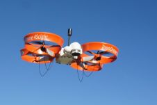
Drone manufacturer ScientificAerospace together with mapping company DroneMetrex from Adelaide, Australia, has developed a photogrammetric mapping solution that offers new possibilities for the geospatial industry. Building on the advantages of ScientificAerospace’s experience...
The Pegasus:Backpack, Leica Geosystems’ wearable reality capture technology, has been honoured with a prestigious Red Dot Design Award for 2016. An independent panel of 41 experts selected the Pegasus:Backpack as...
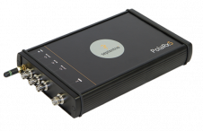
Septentrio Americas has announced the availability of its new PolaRx5 Continuously Operating Reference Station (CORS) platforms optimised for state DOTs and other RTK network operators. The PolaRx5 CORS receivers can...
This site uses cookies. By continuing to use this website, you agree to our Cookies Policy. Agree